Satellite Wildfire Modeling Market
Satellite Wildfire Modeling Market Forecasts to 2032 – Global Analysis By Solution Type (Satellite Imaging & Remote Sensing, Early Warning Systems, Thermal & Infrared Detection, Integrated Fire Management Platforms, and Data Analytics & Predictive Modeling), Satellite Type, Technology, Deployment Mode, Application, End User and By Geography

According to Stratistics MRC, the Global Satellite Wildfire Modeling Market is accounted for $286.25 million in 2025 and is expected to reach $738.55 million by 2032 growing at a CAGR of 14.5% during the forecast period. Satellite Wildfire Modeling refers to the use of satellite-based remote sensing technologies and computational models to detect, monitor, and predict the behavior of wildfires. By analyzing data such as vegetation cover, temperature, wind patterns, and fuel conditions, these models provide real-time insights into wildfire spread, intensity, and potential risks. This technology supports disaster management, environmental protection, and firefighting efforts, enabling authorities to make informed decisions and minimize ecological and human impacts.
Market Dynamics:
Driver:
Increasing frequency of wildfires globally
The rising incidence of wildfires worldwide is intensifying demand for advanced monitoring and modeling tools. Climate change, prolonged droughts, and shifting vegetation patterns are contributing to more frequent and severe fire outbreaks. Governments and environmental agencies are prioritizing early detection systems to mitigate ecological and economic damage. Satellite-based wildfire modeling offers real-time insights, enabling faster response and resource allocation. As fire-prone regions expand, the need for scalable, predictive technologies is becoming urgent. This growing environmental threat is propelling investment into satellite imaging and remote sensing solutions.
Restraint:
High costs of satellite deployment and maintenance
Building and deploying satellite infrastructure requires substantial capital, often limiting access to well-funded institutions or governments. Operational costs, including ground station management and data processing, add to the complexity. These expenses can deter smaller players and slow innovation in wildfire modeling applications. Additionally, the long lifecycle and inflexible upgrade paths of satellites hinder rapid adaptation to evolving fire dynamics. As a result, cost constraints continue to restrict broader market penetration and scalability.
Opportunity:
Integration of AI and machine learning for predictive modeling
AI and machine learning are revolutionizing wildfire prediction by enhancing data interpretation and forecasting accuracy. These technologies can analyze satellite imagery, weather patterns, and vegetation indices to anticipate fire outbreaks. Predictive algorithms enable proactive risk assessment, allowing stakeholders to allocate resources more efficiently. The integration of AI also supports automated anomaly detection, reducing reliance on manual monitoring. As datasets grow in complexity, machine learning models are becoming indispensable for real-time decision-making. This convergence of satellite data and intelligent analytics is unlocking new frontiers in wildfire management.
Threat:
Cybersecurity risks and data breaches
The increasing reliance on satellite systems and cloud-based analytics introduces vulnerabilities to cyberattacks. Unauthorized access to wildfire modeling platforms can compromise sensitive environmental data and disrupt emergency response operations. Hackers targeting satellite communication channels pose risks to data integrity and system reliability. Moreover, breaches can erode public trust and deter investment in digital wildfire solutions. As satellite networks expand, ensuring robust cybersecurity protocols becomes critical. The threat landscape is evolving rapidly, necessitating continuous upgrades to safeguard mission-critical infrastructure.
Covid-19 Impact
The pandemic disrupted satellite deployment schedules and delayed field validation efforts for wildfire modeling systems. Travel restrictions and supply chain interruptions affected hardware procurement and launch timelines. However, Covid-19 also accelerated the adoption of remote sensing and cloud-based analytics, enabling decentralized monitoring. Agencies turned to satellite platforms for continuity in environmental surveillance amid lockdowns. The crisis highlighted the importance of resilient, automated systems for disaster preparedness.
The satellite imaging & remote sensing segment is expected to be the largest during the forecast period
The satellite imaging & remote sensing segment is expected to account for the largest market share during the forecast period, fuelled by cutting-edge remote sensing innovations like hyperspectral and multispectral imaging, thermal detection, and AI-driven vision models. Notable trends include the deployment of machine learning tools such as support vector machines for swift fire identification and the use of vegetation indices like NDFI for refined spectral insights. Recent breakthroughs feature autonomous satellite platforms and deep learning techniques that enhance image clarity and detection precision, supporting more effective wildfire prediction and mitigation strategies.
The commercial forestry & insurance firms segment is expected to have the highest CAGR during the forecast period
Over the forecast period, the commercial forestry & insurance firms segment is predicted to witness the highest growth rate, driven by their need for accurate fire risk modeling and loss mitigation. Satellite data enables these stakeholders to monitor forest health, assess vulnerability, and optimize resource allocation. Insurers are leveraging predictive analytics to refine underwriting and claims processing. Forestry operators use remote sensing to plan firebreaks and evaluate post-fire recovery. As climate volatility increases, these sectors are investing heavily in satellite-based solutions. Their growing reliance on data-driven decision-making is fueling rapid market expansion.
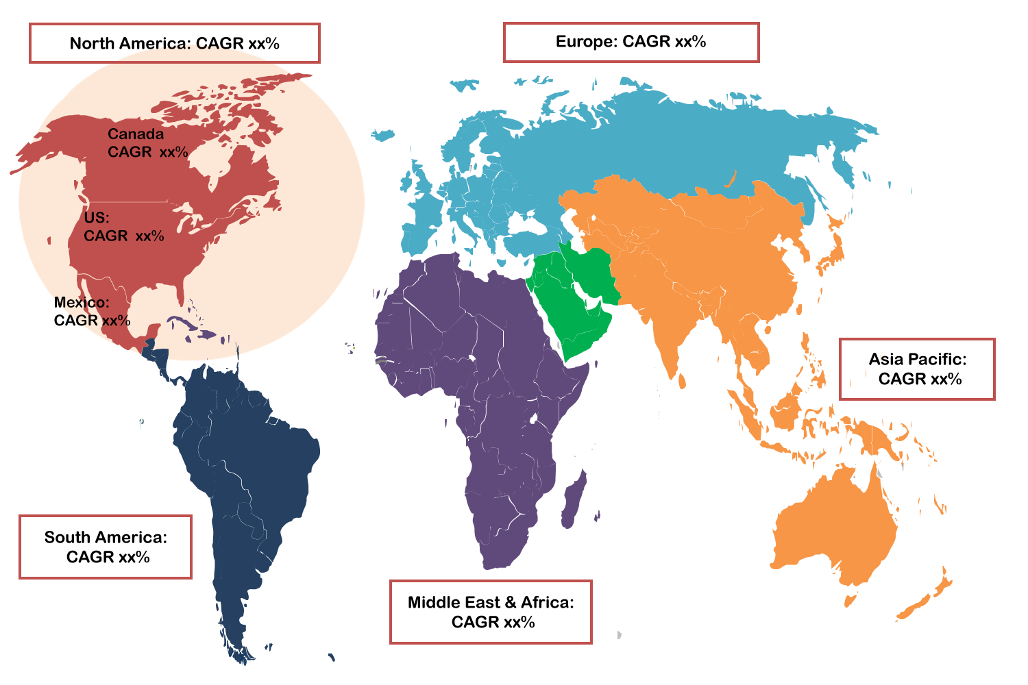
Region with largest share:
During the forecast period, the Asia Pacific region is expected to hold the largest market share due to escalating wildfire risks, climate instability, and the demand for rapid response systems. Advanced technologies such as satellite-based thermal imaging, geospatial mapping, and AI-driven forecasting are at the forefront. Notable trends include drone-assisted surveillance, cloud-native analytics, and integrated sensor networks for enhanced prediction. Regional governments and private stakeholders are ramping up investments in Earth observation infrastructure and collaborative platforms, driving innovation in wildfire detection, preparedness, and resilience strategies.
Region with highest CAGR:
Over the forecast period, the North America region is anticipated to exhibit the highest CAGR, owing to increasing wildfire events, climate-related threats, and the urgency for fast-response solutions. Leading technologies include satellite thermal imaging, geospatial intelligence, and AI-powered forecasting tools. Noteworthy trends involve drone-enabled monitoring, cloud-integrated systems, and real-time sensor fusion. Significant advancements include joint public-private investments in satellite infrastructure, deployment of wildfire-focused constellations, and machine learning algorithms for early detection collectively enhancing regional preparedness and transforming wildfire management capabilities.
Key players in the market
Some of the key players profiled in the Satellite Wildfire Modeling Market include Maxar Technologies, Mitiga Solutions, Planet Labs, Blue Sky Analytics, OroraTech, Umbra, Satellogic, Overstory, Capella Space, CARTO, Spire Global, Descartes Labs, Pano AI, Torch Sensors, and IQ FireWatch.
Key Developments:
In July 2025, OroraTech USA has announced a strategic partnership with Opterrix, a next-generation risk intelligence platform built for the insurance industry. Through this collaboration, OroraTech’s real-time wildfire hotspot data and AI Fire Spread simulations will be integrated directly into Opterrix’s geospatial platform, enhancing situational awareness for insurers and enabling proactive engagement with policyholders at risk.
In June 2025, Maxar Intelligence announced the launch of Sentry™, a first-of-its-kind persistent monitoring solution that delivers strategic operational and threat intelligence at global scale for a real-time decision advantage. Sentry integrates AI-powered capabilities unique to Maxar including multi-source constellation orchestration, geospatial fusion, and advanced machine learning models for automated analytics to deliver a new level of closed-loop spatial intelligence.
Solution Types Covered:
• Satellite Imaging & Remote Sensing
• Early Warning Systems
• Thermal & Infrared Detection
• Integrated Fire Management Platforms
• Data Analytics & Predictive Modeling
Satellite Types Covered:
• Low Earth Orbit (LEO)
• Geostationary Orbit (GEO)
• Medium Earth Orbit (MEO)
Technologies Covered:
• Remote Sensing
• Cloud Computing & Big Data Analytics
• Geographic Information Systems (GIS)
• Artificial Intelligence & Machine Learning (AI/ML)
Deployment Modes Covered:
• On-Premises
• Cloud-Based
Applications Covered:
• Forest Management & Conservation
• Urban-Wildland Interface Risk Assessment
• Disaster Response & Mitigation
• Environmental Monitoring
• Other Applications
End Users Covered:
• Government Agencies
• Commercial Forestry & Insurance Firms
• Environmental NGOs
• Research Institutes & Academia
Regions Covered:
• North America
o US
o Canada
o Mexico
• Europe
o Germany
o UK
o Italy
o France
o Spain
o Rest of Europe
• Asia Pacific
o Japan
o China
o India
o Australia
o New Zealand
o South Korea
o Rest of Asia Pacific
• South America
o Argentina
o Brazil
o Chile
o Rest of South America
• Middle East & Africa
o Saudi Arabia
o UAE
o Qatar
o South Africa
o Rest of Middle East & Africa
What our report offers:
- Market share assessments for the regional and country-level segments
- Strategic recommendations for the new entrants
- Covers Market data for the years 2024, 2025, 2026, 2028, and 2032
- Market Trends (Drivers, Constraints, Opportunities, Threats, Challenges, Investment Opportunities, and recommendations)
- Strategic recommendations in key business segments based on the market estimations
- Competitive landscaping mapping the key common trends
- Company profiling with detailed strategies, financials, and recent developments
- Supply chain trends mapping the latest technological advancements
Free Customization Offerings:
All the customers of this report will be entitled to receive one of the following free customization options:
• Company Profiling
o Comprehensive profiling of additional market players (up to 3)
o SWOT Analysis of key players (up to 3)
• Regional Segmentation
o Market estimations, Forecasts and CAGR of any prominent country as per the client's interest (Note: Depends on feasibility check)
• Competitive Benchmarking
o Benchmarking of key players based on product portfolio, geographical presence, and strategic alliances
Table of Contents
1 Executive Summary
2 Preface
2.1 Abstract
2.2 Stake Holders
2.3 Research Scope
2.4 Research Methodology
2.4.1 Data Mining
2.4.2 Data Analysis
2.4.3 Data Validation
2.4.4 Research Approach
2.5 Research Sources
2.5.1 Primary Research Sources
2.5.2 Secondary Research Sources
2.5.3 Assumptions
3 Market Trend Analysis
3.1 Introduction
3.2 Drivers
3.3 Restraints
3.4 Opportunities
3.5 Threats
3.6 Technology Analysis
3.7 Application Analysis
3.8 End User Analysis
3.9 Emerging Markets
3.10 Impact of Covid-19
4 Porters Five Force Analysis
4.1 Bargaining power of suppliers
4.2 Bargaining power of buyers
4.3 Threat of substitutes
4.4 Threat of new entrants
4.5 Competitive rivalry
5 Global Satellite Wildfire Modeling Market, By Solution Type
5.1 Introduction
5.2 Satellite Imaging & Remote Sensing
5.3 Early Warning Systems
5.4 Thermal & Infrared Detection
5.5 Integrated Fire Management Platforms
5.6 Data Analytics & Predictive Modeling
6 Global Satellite Wildfire Modeling Market, By Satellite Type
6.1 Introduction
6.2 Low Earth Orbit (LEO)
6.3 Geostationary Orbit (GEO)
6.4 Medium Earth Orbit (MEO)
7 Global Satellite Wildfire Modeling Market, By Technology
7.1 Introduction
7.2 Remote Sensing
7.3 Cloud Computing & Big Data Analytics
7.4 Geographic Information Systems (GIS)
7.5 Artificial Intelligence & Machine Learning (AI/ML)
8 Global Satellite Wildfire Modeling Market, By Deployment Mode
8.1 Introduction
8.2 On-Premises
8.3 Cloud-Based
9 Global Satellite Wildfire Modeling Market, By Application
9.1 Introduction
9.2 Forest Management & Conservation
9.3 Urban-Wildland Interface Risk Assessment
9.4 Disaster Response & Mitigation
9.5 Environmental Monitoring
9.6 Other Applications
10 Global Satellite Wildfire Modeling Market, By End User
10.1 Introduction
10.2 Government Agencies
10.3 Commercial Forestry & Insurance Firms
10.4 Environmental NGOs
10.5 Research Institutes & Academia
11 Global Satellite Wildfire Modeling Market, By Geography
11.1 Introduction
11.2 North America
11.2.1 US
11.2.2 Canada
11.2.3 Mexico
11.3 Europe
11.3.1 Germany
11.3.2 UK
11.3.3 Italy
11.3.4 France
11.3.5 Spain
11.3.6 Rest of Europe
11.4 Asia Pacific
11.4.1 Japan
11.4.2 China
11.4.3 India
11.4.4 Australia
11.4.5 New Zealand
11.4.6 South Korea
11.4.7 Rest of Asia Pacific
11.5 South America
11.5.1 Argentina
11.5.2 Brazil
11.5.3 Chile
11.5.4 Rest of South America
11.6 Middle East & Africa
11.6.1 Saudi Arabia
11.6.2 UAE
11.6.3 Qatar
11.6.4 South Africa
11.6.5 Rest of Middle East & Africa
12 Key Developments
12.1 Agreements, Partnerships, Collaborations and Joint Ventures
12.2 Acquisitions & Mergers
12.3 New Product Launch
12.4 Expansions
12.5 Other Key Strategies
13 Company Profiling
13.1 Maxar Technologies
13.2 Mitiga Solutions
13.3 Planet Labs
13.4 Blue Sky Analytics
13.5 OroraTech
13.6 Umbra
13.7 Satellogic
13.8 Overstory
13.9 Capella Space
13.10 CARTO
13.11 Spire Global
13.12 Descartes Labs
13.13 Pano AI
13.14 Torch Sensors
13.15 IQ FireWatch
List of Tables
1 Global Satellite Wildfire Modeling Market Outlook, By Region (2024-2032) ($MN)
2 Global Satellite Wildfire Modeling Market Outlook, By Solution Type (2024-2032) ($MN)
3 Global Satellite Wildfire Modeling Market Outlook, By Satellite Imaging & Remote Sensing (2024-2032) ($MN)
4 Global Satellite Wildfire Modeling Market Outlook, By Early Warning Systems (2024-2032) ($MN)
5 Global Satellite Wildfire Modeling Market Outlook, By Thermal & Infrared Detection (2024-2032) ($MN)
6 Global Satellite Wildfire Modeling Market Outlook, By Integrated Fire Management Platforms (2024-2032) ($MN)
7 Global Satellite Wildfire Modeling Market Outlook, By Data Analytics & Predictive Modeling (2024-2032) ($MN)
8 Global Satellite Wildfire Modeling Market Outlook, By Satellite Type (2024-2032) ($MN)
9 Global Satellite Wildfire Modeling Market Outlook, By Low Earth Orbit (LEO) (2024-2032) ($MN)
10 Global Satellite Wildfire Modeling Market Outlook, By Geostationary Orbit (GEO) (2024-2032) ($MN)
11 Global Satellite Wildfire Modeling Market Outlook, By Medium Earth Orbit (MEO) (2024-2032) ($MN)
12 Global Satellite Wildfire Modeling Market Outlook, By Technology (2024-2032) ($MN)
13 Global Satellite Wildfire Modeling Market Outlook, By Remote Sensing (2024-2032) ($MN)
14 Global Satellite Wildfire Modeling Market Outlook, By Cloud Computing & Big Data Analytics (2024-2032) ($MN)
15 Global Satellite Wildfire Modeling Market Outlook, By Geographic Information Systems (GIS) (2024-2032) ($MN)
16 Global Satellite Wildfire Modeling Market Outlook, By Artificial Intelligence & Machine Learning (AI/ML) (2024-2032) ($MN)
17 Global Satellite Wildfire Modeling Market Outlook, By Deployment Mode (2024-2032) ($MN)
18 Global Satellite Wildfire Modeling Market Outlook, By On-Premises (2024-2032) ($MN)
19 Global Satellite Wildfire Modeling Market Outlook, By Cloud-Based (2024-2032) ($MN)
20 Global Satellite Wildfire Modeling Market Outlook, By Application (2024-2032) ($MN)
21 Global Satellite Wildfire Modeling Market Outlook, By Forest Management & Conservation (2024-2032) ($MN)
22 Global Satellite Wildfire Modeling Market Outlook, By Urban-Wildland Interface Risk Assessment (2024-2032) ($MN)
23 Global Satellite Wildfire Modeling Market Outlook, By Disaster Response & Mitigation (2024-2032) ($MN)
24 Global Satellite Wildfire Modeling Market Outlook, By Environmental Monitoring (2024-2032) ($MN)
25 Global Satellite Wildfire Modeling Market Outlook, By Other Applications (2024-2032) ($MN)
26 Global Satellite Wildfire Modeling Market Outlook, By End User (2024-2032) ($MN)
27 Global Satellite Wildfire Modeling Market Outlook, By Government Agencies (2024-2032) ($MN)
28 Global Satellite Wildfire Modeling Market Outlook, By Commercial Forestry & Insurance Firms (2024-2032) ($MN)
29 Global Satellite Wildfire Modeling Market Outlook, By Environmental NGOs (2024-2032) ($MN)
30 Global Satellite Wildfire Modeling Market Outlook, By Research Institutes & Academia (2024-2032) ($MN)
Note: Tables for North America, Europe, APAC, South America, and Middle East & Africa Regions are also represented in the same manner as above.
List of Figures
RESEARCH METHODOLOGY
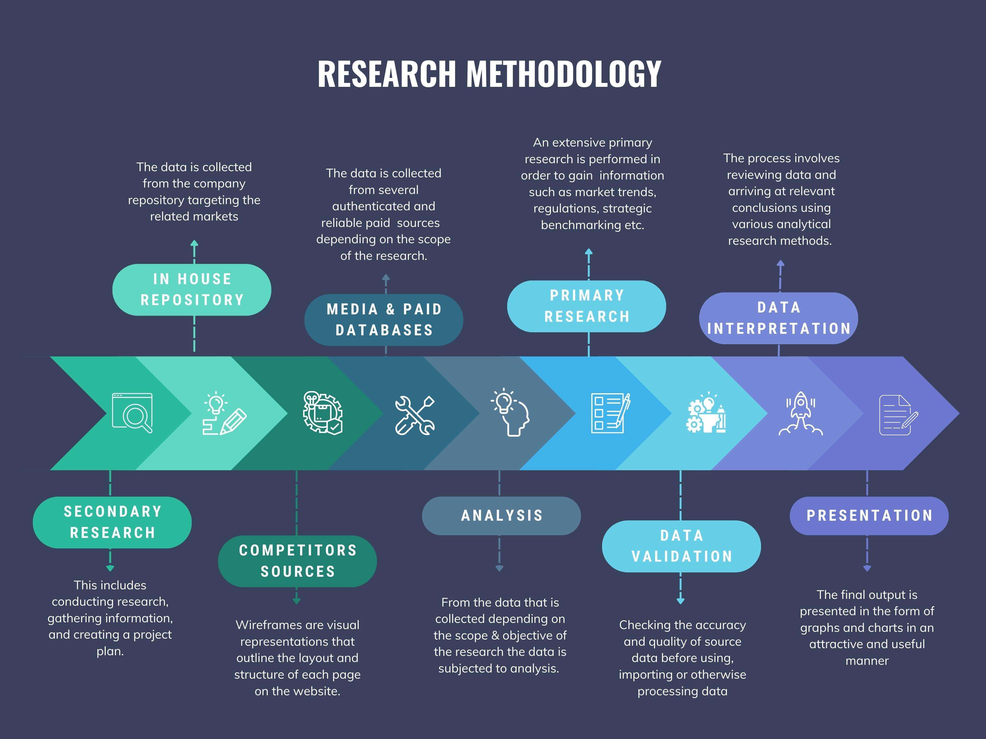
We at ‘Stratistics’ opt for an extensive research approach which involves data mining, data validation, and data analysis. The various research sources include in-house repository, secondary research, competitor’s sources, social media research, client internal data, and primary research.
Our team of analysts prefers the most reliable and authenticated data sources in order to perform the comprehensive literature search. With access to most of the authenticated data bases our team highly considers the best mix of information through various sources to obtain extensive and accurate analysis.
Each report takes an average time of a month and a team of 4 industry analysts. The time may vary depending on the scope and data availability of the desired market report. The various parameters used in the market assessment are standardized in order to enhance the data accuracy.
Data Mining
The data is collected from several authenticated, reliable, paid and unpaid sources and is filtered depending on the scope & objective of the research. Our reports repository acts as an added advantage in this procedure. Data gathering from the raw material suppliers, distributors and the manufacturers is performed on a regular basis, this helps in the comprehensive understanding of the products value chain. Apart from the above mentioned sources the data is also collected from the industry consultants to ensure the objective of the study is in the right direction.
Market trends such as technological advancements, regulatory affairs, market dynamics (Drivers, Restraints, Opportunities and Challenges) are obtained from scientific journals, market related national & international associations and organizations.
Data Analysis
From the data that is collected depending on the scope & objective of the research the data is subjected for the analysis. The critical steps that we follow for the data analysis include:
- Product Lifecycle Analysis
- Competitor analysis
- Risk analysis
- Porters Analysis
- PESTEL Analysis
- SWOT Analysis
The data engineering is performed by the core industry experts considering both the Marketing Mix Modeling and the Demand Forecasting. The marketing mix modeling makes use of multiple-regression techniques to predict the optimal mix of marketing variables. Regression factor is based on a number of variables and how they relate to an outcome such as sales or profits.
Data Validation
The data validation is performed by the exhaustive primary research from the expert interviews. This includes telephonic interviews, focus groups, face to face interviews, and questionnaires to validate our research from all aspects. The industry experts we approach come from the leading firms, involved in the supply chain ranging from the suppliers, distributors to the manufacturers and consumers so as to ensure an unbiased analysis.
We are in touch with more than 15,000 industry experts with the right mix of consultants, CEO's, presidents, vice presidents, managers, experts from both supply side and demand side, executives and so on.
The data validation involves the primary research from the industry experts belonging to:
- Leading Companies
- Suppliers & Distributors
- Manufacturers
- Consumers
- Industry/Strategic Consultants
Apart from the data validation the primary research also helps in performing the fill gap research, i.e. providing solutions for the unmet needs of the research which helps in enhancing the reports quality.
For more details about research methodology, kindly write to us at info@strategymrc.com
Frequently Asked Questions
In case of any queries regarding this report, you can contact the customer service by filing the “Inquiry Before Buy” form available on the right hand side. You may also contact us through email: info@strategymrc.com or phone: +1-301-202-5929
Yes, the samples are available for all the published reports. You can request them by filling the “Request Sample” option available in this page.
Yes, you can request a sample with your specific requirements. All the customized samples will be provided as per the requirement with the real data masked.
All our reports are available in Digital PDF format. In case if you require them in any other formats, such as PPT, Excel etc you can submit a request through “Inquiry Before Buy” form available on the right hand side. You may also contact us through email: info@strategymrc.com or phone: +1-301-202-5929
We offer a free 15% customization with every purchase. This requirement can be fulfilled for both pre and post sale. You may send your customization requirements through email at info@strategymrc.com or call us on +1-301-202-5929.
We have 3 different licensing options available in electronic format.
- Single User Licence: Allows one person, typically the buyer, to have access to the ordered product. The ordered product cannot be distributed to anyone else.
- 2-5 User Licence: Allows the ordered product to be shared among a maximum of 5 people within your organisation.
- Corporate License: Allows the product to be shared among all employees of your organisation regardless of their geographical location.
All our reports are typically be emailed to you as an attachment.
To order any available report you need to register on our website. The payment can be made either through CCAvenue or PayPal payments gateways which accept all international cards.
We extend our support to 6 months post sale. A post sale customization is also provided to cover your unmet needs in the report.
Request Customization
We offer complimentary customization of up to 15% with every purchase. To share your customization requirements, feel free to email us at info@strategymrc.com or call us on +1-301-202-5929. .
Please Note: Customization within the 15% threshold is entirely free of charge. If your request exceeds this limit, we will conduct a feasibility assessment. Following that, a detailed quote and timeline will be provided.
WHY CHOOSE US ?

Assured Quality
Best in class reports with high standard of research integrity

24X7 Research Support
Continuous support to ensure the best customer experience.

Free Customization
Adding more values to your product of interest.

Safe & Secure Access
Providing a secured environment for all online transactions.

Trusted by 600+ Brands
Serving the most reputed brands across the world.