
Agriculture Drone Mapping Applications Market
Agriculture Drone Mapping Applications Market Forecasts to 2034 - Global Analysis By Drone Type (Fixed-Wing Drones, Rotary-Wing Drones and Hybrid Drones), Technology, Mapping Application, End User and By Geography

According to Stratistics MRC, the Global Agriculture Drone Mapping Applications Market is accounted for $2.5 billion in 2026 and is expected to reach $10.1 billion by 2034 growing at a CAGR of 19.0% during the forecast period. Agriculture Drone Mapping Applications involve the deployment of unmanned aerial systems fitted with sensors and cameras to collect precise spatial data from agricultural fields. These systems create detailed field maps that assist in evaluating crop health, soil variability, water distribution, and pest presence. By interpreting aerial data, farmers can detect inconsistencies across farmland and implement informed strategies to enhance productivity and optimize inputs. Drone-based mapping supports precision farming by enabling accurate application of fertilizers and pesticides only where needed. This approach reduces operational costs, minimizes resource waste, improves efficiency, and promotes sustainable agricultural practices through continuous monitoring and data-driven decision-making in farming.
According to the Food and Agriculture Organization (FAO), precision agriculture technologies, including UAV‑based mapping, can reduce input use by up to 30% while maintaining or increasing yields, making them vital for sustainable resource management in global agriculture.
Market Dynamics:
Driver:
Rising demand for precision farming
The growing shift toward precision farming significantly drives the agriculture drone mapping market. Farmers are increasingly relying on data-based cultivation methods to enhance productivity while minimizing resource usage. Drone mapping technologies deliver detailed insights into soil conditions, crop health variations, irrigation patterns, and pest activity across fields. These insights enable farmers to apply inputs like water, fertilizers, and pesticides more accurately and efficiently. Drone-based mapping supports faster, informed decision-making, reduces agricultural waste, and improves operational efficiency across both small farms and large-scale commercial agricultural systems globally.
Restraint:
Lack of technical knowledge among farmers
Insufficient technical expertise among farmers acts as a major barrier to the growth of the agriculture drone mapping market. Many rural farmers lack experience in operating drones and analyzing the data they generate. Effective use of drone mapping requires familiarity with specialized software, analytics tools, and precision farming methods, which are often unfamiliar to traditional agricultural workers. Limited training opportunities and low digital literacy further worsen this challenge. As a result, farmers may struggle to fully utilize drone capabilities or avoid adoption entirely. This knowledge gap significantly hampers the widespread implementation of drone-based solutions in agriculture.
Opportunity:
Expansion of precision agriculture practices
The increasing adoption of precision agriculture offers strong growth opportunities for the agriculture drone mapping market. With rising global food demand, farmers are turning to advanced technologies to improve yield and efficiently manage resources. Drone mapping supports precision farming by delivering real-time and accurate insights into crop health, soil conditions, and water distribution. These insights help farmers apply fertilizers, pesticides, and irrigation more precisely. Growing awareness of sustainable farming and the need for higher productivity with fewer resources is driving the use of drone technologies. This trend is encouraging widespread adoption of drone-based agricultural solutions across farms of all sizes globally.
Threat:
Rapid technological obsolescence
Fast-paced technological changes present a major threat to the agriculture drone mapping market. Drone systems, including sensors, cameras, and software, are improving rapidly, making older models obsolete in a short time. This forces frequent upgrades, increasing costs for both companies and farmers. Such continuous advancements create financial pressure and make long-term investment planning difficult. Small-scale farmers and businesses often find it hard to keep up with evolving technologies, slowing down adoption rates. At the same time, manufacturers must constantly innovate to remain competitive, which raises development costs and affects overall market stability and profitability in the long run.
Covid-19 Impact:
The COVID-19 outbreak created both challenges and opportunities for the agriculture drone mapping market. In the early stages, lockdowns, supply chain disruptions, and manufacturing slowdowns affected drone production and field usage. Farmers also reduced spending on advanced technologies due to financial uncertainty. However, the pandemic emphasized the need for automation and remote farming solutions. Drone mapping became valuable for monitoring crops without direct human contact, lowering labour requirements and improving safety. As conditions stabilized, interest in precision agriculture increased significantly. Overall, while COVID-19 temporarily slowed market activities, it ultimately strengthened long-term adoption of drone-based agricultural technologies worldwide.
The rotary-wing drones segment is expected to be the largest during the forecast period
The rotary-wing drones segment is expected to account for the largest market share during the forecast period because of their superior maneuverability and operational flexibility. These drones can hover steadily in one place, allowing highly accurate field inspection and crop monitoring. Their vertical takeoff and landing capability removes the need for runways, making them practical for diverse farming environments. They are especially effective for surveying specific sections of farmland, which makes them suitable for precision agriculture in small and medium-scale farms. Their adaptability across different agricultural conditions contributes significantly to their leading market position worldwide.
The pest & disease detection segment is expected to have the highest CAGR during the forecast period
Over the forecast period, the pest & disease detection segment is predicted to witness the highest growth rate because of the rising focus on early crop protection. Farmers are increasingly using drones equipped with advanced imaging technologies to identify pest attacks and disease spread at an early stage across extensive farmlands. Multispectral and thermal sensors help detect subtle plant stress that is difficult to observe manually. Early identification allows quick treatment, reducing crop losses and enhancing productivity. Concerns about food security and the need to limit excessive chemical use are also boosting demand, making this segment highly dynamic and fast-growing globally.
Region with largest share:
During the forecast period, the North America region is expected to hold the largest market share owing to its highly developed farming infrastructure and strong use of precision agriculture techniques. The region is characterized by large commercial farming operations that rely heavily on drones for monitoring crops, analyzing soil conditions, and improving yield efficiency. Government initiatives supporting smart farming and agricultural innovation further contribute to market expansion. The United States plays a leading role with widespread deployment of drone technologies across farms. In addition, the presence of major drone manufacturers and technology companies supports growth.
Region with highest CAGR:
Over the forecast period, the Asia-Pacific region is anticipated to exhibit the highest CAGR, driven by strong adoption of advanced farming practices and supportive government initiatives. Countries like China, India, and Japan are investing heavily in smart agriculture technologies to enhance food production and ensure food security. The region’s large agricultural sector creates significant demand for efficient monitoring and management solutions. Growing awareness of precision farming techniques and financial incentives for drone adoption are boosting usage. Furthermore, rural labour shortages are pushing farmers toward automation, while improving digital infrastructure is enabling wider implementation of drone-based mapping systems across the region.
Key players in the market
Some of the key players in Agriculture Drone Mapping Applications Market include AgEagle Aerial Systems Inc., DroneDeploy, Eagletronics, Fuselage Innovations, NONG Precision Agriculture, Predulive Labs, Terra Drone Arabia, Vyom Drones Pvt. Ltd., Aeroyantra, Dronelab, DJI Agriculture, Trimble Inc., PrecisionHawk, senseFly, Pix4D, Wingtra, Garuda Aerospace and IdeaForge.
Key Developments:
In June 2026, Garuda Technologies has signed a Memorandum of Understanding (MoU) with Extensee SAS, a provider of drone manufacturing and operational services, at Eurosatory 2026 in Paris, France – one of the world’s leading international defence and security exhibitions. The collaboration will focus on enabling long-range intelligence, surveillance and reconnaissance (ISR), mapping, infrastructure inspection, environmental monitoring, border security, and other commercial and government applications.
In November 2025, Trimble strengthens global footprint through partnership with Liverpool FC. Under the agreement, Trimble has become a global partner of Liverpool, with its branding featuring across the club’s home ground and on the digital platforms.
In July 2025, AgEagle Aerial Systems Inc. announces the upcoming demonstration of AI-enabled autonomous Unmanned Aircraft System (UAS) teaming, developed through a strategic partnership with an Israeli defense/technology firm. The system is designed for use in border security, surveillance, and intrusion detection missions and will showcase advanced autonomous capabilities with minimal human intervention while delivering real-time operational intelligence.
Drone Types Covered:
• Fixed-Wing Drones
• Rotary-Wing Drones
• Hybrid Drones
Technologies Covered:
• Multispectral Imaging
• Hyperspectral Imaging
• LiDAR Mapping
• Photogrammetry
Mapping Applications Covered:
• Crop Health Monitoring
• Soil & Field Analysis
• Plant Counting & Yield Estimation
• Irrigation Planning
• Pest & Disease Detection
• Topographic & Boundary Mapping
End Users Covered:
• Large-Scale Commercial Farms
• Small & Medium Farms
• Agricultural Cooperatives
• Research Institutions & Government Agencies
Regions Covered:
• North America
o United States
o Canada
o Mexico
• Europe
o United Kingdom
o Germany
o France
o Italy
o Spain
o Netherlands
o Belgium
o Sweden
o Switzerland
o Poland
o Rest of Europe
• Asia Pacific
o China
o Japan
o India
o South Korea
o Australia
o Indonesia
o Thailand
o Malaysia
o Singapore
o Vietnam
o Rest of Asia Pacific
• South America
o Brazil
o Argentina
o Colombia
o Chile
o Peru
o Rest of South America
• Rest of the World (RoW)
o Middle East
§ Saudi Arabia
§ United Arab Emirates
§ Qatar
§ Israel
§ Rest of Middle East
o Africa
§ South Africa
§ Egypt
§ Morocco
§ Rest of Africa
What our report offers:
- Market share assessments for the regional and country-level segments
- Strategic recommendations for the new entrants
- Covers Market data for the years 2023, 2024, 2025, 2026, 2027, 2028, 2030, 2032 and 2034
- Market Trends (Drivers, Constraints, Opportunities, Threats, Challenges, Investment Opportunities, and recommendations)
- Strategic recommendations in key business segments based on the market estimations
- Competitive landscaping mapping the key common trends
- Company profiling with detailed strategies, financials, and recent developments
- Supply chain trends mapping the latest technological advancements
Free Customization Offerings:
All the customers of this report will be entitled to receive one of the following free customization options:
• Company Profiling
o Comprehensive profiling of additional market players (up to 3)
o SWOT Analysis of key players (up to 3)
• Regional Segmentation
o Market estimations, Forecasts and CAGR of any prominent country as per the client's interest (Note: Depends on feasibility check)
• Competitive Benchmarking
o Benchmarking of key players based on product portfolio, geographical presence, and strategic alliances
Table of Contents
1 Executive Summary
1.1 Market Snapshot and Key Highlights
1.2 Growth Drivers, Challenges, and Opportunities
1.3 Competitive Landscape Overview
1.4 Strategic Insights and Recommendations
2 Research Framework
2.1 Study Objectives and Scope
2.2 Stakeholder Analysis
2.3 Research Assumptions and Limitations
2.4 Research Methodology
2.4.1 Data Collection (Primary and Secondary)
2.4.2 Data Modeling and Estimation Techniques
2.4.3 Data Validation and Triangulation
2.4.4 Analytical and Forecasting Approach
3 Market Dynamics and Trend Analysis
3.1 Market Definition and Structure
3.2 Key Market Drivers
3.3 Market Restraints and Challenges
3.4 Growth Opportunities and Investment Hotspots
3.5 Industry Threats and Risk Assessment
3.6 Technology and Innovation Landscape
3.7 Emerging and High-Growth Markets
3.8 Regulatory and Policy Environment
3.9 Impact of COVID-19 and Recovery Outlook
4 Competitive and Strategic Assessment
4.1 Porter's Five Forces Analysis
4.1.1 Supplier Bargaining Power
4.1.2 Buyer Bargaining Power
4.1.3 Threat of Substitutes
4.1.4 Threat of New Entrants
4.1.5 Competitive Rivalry
4.2 Market Share Analysis of Key Players
4.3 Product Benchmarking and Performance Comparison
5 Global Agriculture Drone Mapping Applications Market, By Drone Type
5.1 Fixed-Wing Drones
5.2 Rotary-Wing Drones
5.3 Hybrid Drones
6 Global Agriculture Drone Mapping Applications Market, By Technology
6.1 Multispectral Imaging
6.2 Hyperspectral Imaging
6.3 LiDAR Mapping
6.4 Photogrammetry
7 Global Agriculture Drone Mapping Applications Market, By Mapping Application
7.1 Crop Health Monitoring
7.2 Soil & Field Analysis
7.3 Plant Counting & Yield Estimation
7.4 Irrigation Planning
7.5 Pest & Disease Detection
7.6 Topographic & Boundary Mapping
8 Global Agriculture Drone Mapping Applications Market, By End User
8.1 Large-Scale Commercial Farms
8.2 Small & Medium Farms
8.3 Agricultural Cooperatives
8.4 Research Institutions & Government Agencies
9 Global Agriculture Drone Mapping Applications Market, By Geography
9.1 North America
9.1.1 United States
9.1.2 Canada
9.1.3 Mexico
9.2 Europe
9.2.1 United Kingdom
9.2.2 Germany
9.2.3 France
9.2.4 Italy
9.2.5 Spain
9.2.6 Netherlands
9.2.7 Belgium
9.2.8 Sweden
9.2.9 Switzerland
9.2.10 Poland
9.2.11 Rest of Europe
9.3 Asia Pacific
9.3.1 China
9.3.2 Japan
9.3.3 India
9.3.4 South Korea
9.3.5 Australia
9.3.6 Indonesia
9.3.7 Thailand
9.3.8 Malaysia
9.3.9 Singapore
9.3.10 Vietnam
9.3.11 Rest of Asia Pacific
9.4 South America
9.4.1 Brazil
9.4.2 Argentina
9.4.3 Colombia
9.4.4 Chile
9.4.5 Peru
9.4.6 Rest of South America
9.5 Rest of the World (RoW)
9.5.1 Middle East
9.5.1.1 Saudi Arabia
9.5.1.2 United Arab Emirates
9.5.1.3 Qatar
9.5.1.4 Israel
9.5.1.5 Rest of Middle East
9.5.2 Africa
9.5.2.1 South Africa
9.5.2.2 Egypt
9.5.2.3 Morocco
9.5.2.4 Rest of Africa
10 Strategic Market Intelligence
10.1 Industry Value Network and Supply Chain Assessment
10.2 White-Space and Opportunity Mapping
10.3 Product Evolution and Market Life Cycle Analysis
10.4 Channel, Distributor, and Go-to-Market Assessment
11 Industry Developments and Strategic Initiatives
11.1 Mergers and Acquisitions
11.2 Partnerships, Alliances, and Joint Ventures
11.3 New Product Launches and Certifications
11.4 Capacity Expansion and Investments
11.5 Other Strategic Initiatives
12 Company Profiles
12.1 AgEagle Aerial Systems Inc.
12.2 DroneDeploy
12.3 Eagletronics
12.4 Fuselage Innovations
12.5 NONG Precision Agriculture
12.6 Predulive Labs
12.7 Terra Drone Arabia
12.8 Vyom Drones Pvt. Ltd.
12.9 Aeroyantra
12.10 Dronelab
12.11 DJI Agriculture
12.12 Trimble Inc.
12.13 PrecisionHawk
12.14 senseFly
12.15 Pix4D
12.16 Wingtra
12.17 Garuda Aerospace
12.18 IdeaForge
List of Tables
1 Global Agriculture Drone Mapping Applications Market Outlook, By Region (2023-2034) ($MN)
2 Global Agriculture Drone Mapping Applications Market Outlook, By Drone Type (2023-2034) ($MN)
3 Global Agriculture Drone Mapping Applications Market Outlook, By Fixed-Wing Drones (2023-2034) ($MN)
4 Global Agriculture Drone Mapping Applications Market Outlook, By Rotary-Wing Drones (2023-2034) ($MN)
5 Global Agriculture Drone Mapping Applications Market Outlook, By Hybrid Drones (2023-2034) ($MN)
6 Global Agriculture Drone Mapping Applications Market Outlook, By Technology (2023-2034) ($MN)
7 Global Agriculture Drone Mapping Applications Market Outlook, By Multispectral Imaging (2023-2034) ($MN)
8 Global Agriculture Drone Mapping Applications Market Outlook, By Hyperspectral Imaging (2023-2034) ($MN)
9 Global Agriculture Drone Mapping Applications Market Outlook, By LiDAR Mapping (2023-2034) ($MN)
10 Global Agriculture Drone Mapping Applications Market Outlook, By Photogrammetry (2023-2034) ($MN)
11 Global Agriculture Drone Mapping Applications Market Outlook, By Mapping Application (2023-2034) ($MN)
12 Global Agriculture Drone Mapping Applications Market Outlook, By Crop Health Monitoring (2023-2034) ($MN)
13 Global Agriculture Drone Mapping Applications Market Outlook, By Soil & Field Analysis (2023-2034) ($MN)
14 Global Agriculture Drone Mapping Applications Market Outlook, By Plant Counting & Yield Estimation (2023-2034) ($MN)
15 Global Agriculture Drone Mapping Applications Market Outlook, By Irrigation Planning (2023-2034) ($MN)
16 Global Agriculture Drone Mapping Applications Market Outlook, By Pest & Disease Detection (2023-2034) ($MN)
17 Global Agriculture Drone Mapping Applications Market Outlook, By Topographic & Boundary Mapping (2023-2034) ($MN)
18 Global Agriculture Drone Mapping Applications Market Outlook, By End User (2023-2034) ($MN)
19 Global Agriculture Drone Mapping Applications Market Outlook, By Large-Scale Commercial Farms (2023-2034) ($MN)
20 Global Agriculture Drone Mapping Applications Market Outlook, By Small & Medium Farms (2023-2034) ($MN)
21 Global Agriculture Drone Mapping Applications Market Outlook, By Agricultural Cooperatives (2023-2034) ($MN)
22 Global Agriculture Drone Mapping Applications Market Outlook, By Research Institutions & Government Agencies (2023-2034) ($MN)
Note: Tables for North America, Europe, APAC, South America, and Rest of the World (RoW) Regions are also represented in the same manner as above.
List of Figures
RESEARCH METHODOLOGY
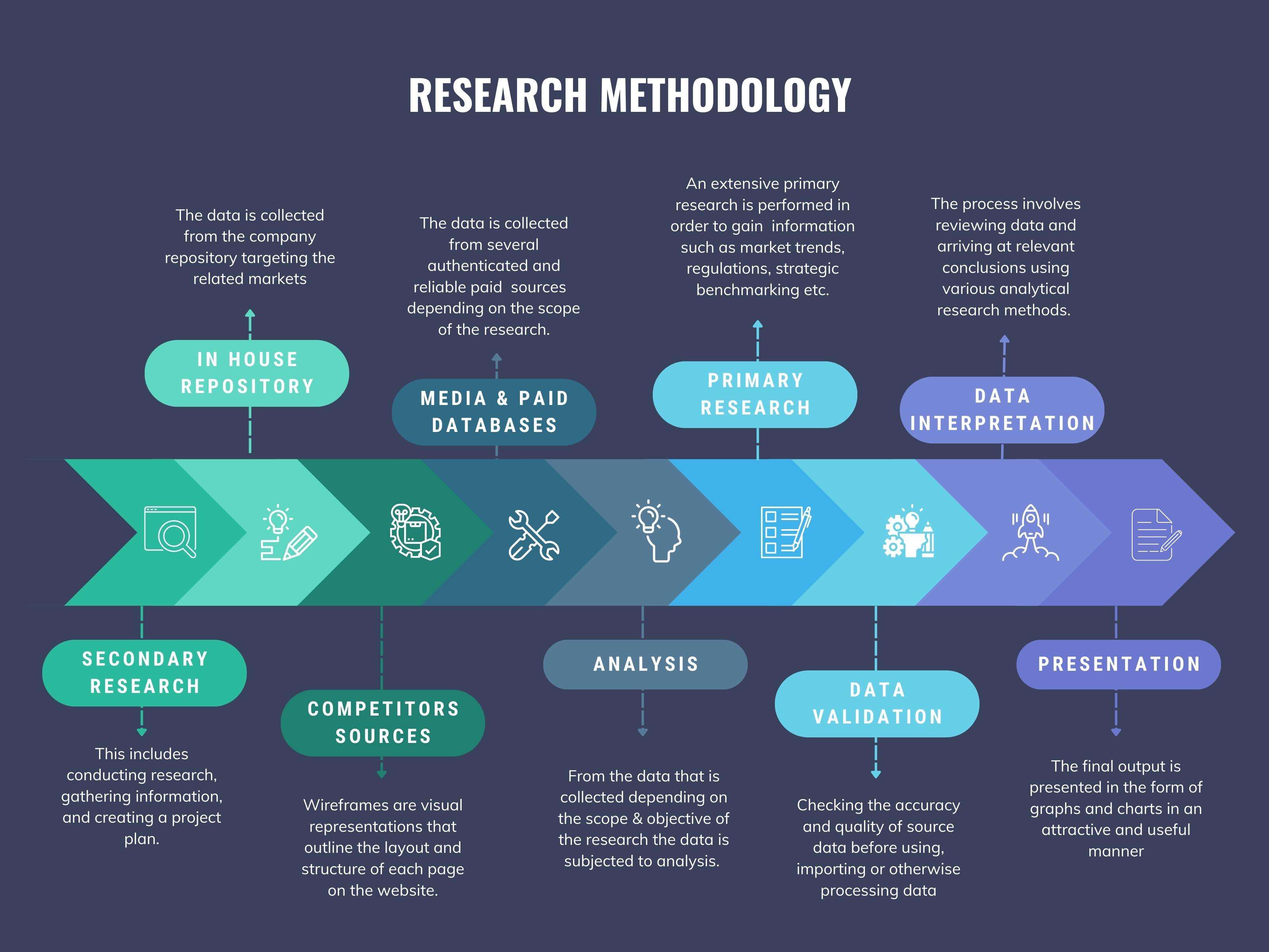
We at ‘Stratistics’ opt for an extensive research approach which involves data mining, data validation, and data analysis. The various research sources include in-house repository, secondary research, competitor’s sources, social media research, client internal data, and primary research.
Our team of analysts prefers the most reliable and authenticated data sources in order to perform the comprehensive literature search. With access to most of the authenticated data bases our team highly considers the best mix of information through various sources to obtain extensive and accurate analysis.
Each report takes an average time of a month and a team of 4 industry analysts. The time may vary depending on the scope and data availability of the desired market report. The various parameters used in the market assessment are standardized in order to enhance the data accuracy.
Data Mining
The data is collected from several authenticated, reliable, paid and unpaid sources and is filtered depending on the scope & objective of the research. Our reports repository acts as an added advantage in this procedure. Data gathering from the raw material suppliers, distributors and the manufacturers is performed on a regular basis, this helps in the comprehensive understanding of the products value chain. Apart from the above mentioned sources the data is also collected from the industry consultants to ensure the objective of the study is in the right direction.
Market trends such as technological advancements, regulatory affairs, market dynamics (Drivers, Restraints, Opportunities and Challenges) are obtained from scientific journals, market related national & international associations and organizations.
Data Analysis
From the data that is collected depending on the scope & objective of the research the data is subjected for the analysis. The critical steps that we follow for the data analysis include:
- Product Lifecycle Analysis
- Competitor analysis
- Risk analysis
- Porters Analysis
- PESTEL Analysis
- SWOT Analysis
The data engineering is performed by the core industry experts considering both the Marketing Mix Modeling and the Demand Forecasting. The marketing mix modeling makes use of multiple-regression techniques to predict the optimal mix of marketing variables. Regression factor is based on a number of variables and how they relate to an outcome such as sales or profits.
Data Validation
The data validation is performed by the exhaustive primary research from the expert interviews. This includes telephonic interviews, focus groups, face to face interviews, and questionnaires to validate our research from all aspects. The industry experts we approach come from the leading firms, involved in the supply chain ranging from the suppliers, distributors to the manufacturers and consumers so as to ensure an unbiased analysis.
We are in touch with more than 15,000 industry experts with the right mix of consultants, CEO's, presidents, vice presidents, managers, experts from both supply side and demand side, executives and so on.
The data validation involves the primary research from the industry experts belonging to:
- Leading Companies
- Suppliers & Distributors
- Manufacturers
- Consumers
- Industry/Strategic Consultants
Apart from the data validation the primary research also helps in performing the fill gap research, i.e. providing solutions for the unmet needs of the research which helps in enhancing the reports quality.
For more details about research methodology, kindly write to us at info@strategymrc.com
Frequently Asked Questions
In case of any queries regarding this report, you can contact the customer service by filing the “Inquiry Before Buy” form available on the right hand side. You may also contact us through email: info@strategymrc.com or phone: +1-301-202-5929
Yes, the samples are available for all the published reports. You can request them by filling the “Request Sample” option available in this page.
Yes, you can request a sample with your specific requirements. All the customized samples will be provided as per the requirement with the real data masked.
All our reports are available in Digital PDF format. In case if you require them in any other formats, such as PPT, Excel etc you can submit a request through “Inquiry Before Buy” form available on the right hand side. You may also contact us through email: info@strategymrc.com or phone: +1-301-202-5929
We offer a free 15% customization with every purchase. This requirement can be fulfilled for both pre and post sale. You may send your customization requirements through email at info@strategymrc.com or call us on +1-301-202-5929.
We have 3 different licensing options available in electronic format.
- Single User Licence: Allows one person, typically the buyer, to have access to the ordered product. The ordered product cannot be distributed to anyone else.
- 2-5 User Licence: Allows the ordered product to be shared among a maximum of 5 people within your organisation.
- Corporate License: Allows the product to be shared among all employees of your organisation regardless of their geographical location.
All our reports are typically be emailed to you as an attachment.
To order any available report you need to register on our website. The payment can be made either through CCAvenue or PayPal payments gateways which accept all international cards.
We extend our support to 6 months post sale. A post sale customization is also provided to cover your unmet needs in the report.
Request Customization
We offer complimentary customization of up to 15% with every purchase. To share your customization requirements, feel free to email us at info@strategymrc.com or call us on +1-301-202-5929. .
Please Note: Customization within the 15% threshold is entirely free of charge. If your request exceeds this limit, we will conduct a feasibility assessment. Following that, a detailed quote and timeline will be provided.
WHY CHOOSE US ?

Assured Quality
Best in class reports with high standard of research integrity

24X7 Research Support
Continuous support to ensure the best customer experience.

Free Customization
Adding more values to your product of interest.

Safe & Secure Access
Providing a secured environment for all online transactions.

Trusted by 600+ Brands
Serving the most reputed brands across the world.