
Airborne Lidar Market
Airborne Lidar Market Forecasts to 2034 - Global Analysis By Platform (Fixed-Wing Aircraft, Rotary-Wing Aircraft, Unmanned Aerial Vehicles (UAVs) / Drones, and Helicopters), LiDAR Type, Component, Application and By Geography

"According to Stratistics MRC, the Global Airborne Lidar Market is accounted for $3.13 billion in 2026 and is expected to reach $7.41 billion by 2034 growing at a CAGR of 11.3% during the forecast period. Airborne LiDAR is an aerial laser-based surveying technology that captures detailed spatial information about the Earth’s surface and objects. Mounted on aircraft, the system emits rapid laser pulses toward the ground and calculates distances by measuring the return time of reflected signals. This process generates high-resolution three-dimensional models of terrain and surface features. The technology supports applications such as topographic mapping, environmental monitoring, forestry analysis, flood modeling, urban planning, and infrastructure development across large and hard-to-reach areas.
Market Dynamics:
Driver:
Growing demand for high-precision geospatial data
Due to the escalating need for accurate, high-resolution 3D terrain models and digital elevation data for planning, surveying, and monitoring. Traditional surveying methods are often time-consuming and less comprehensive. Airborne LiDAR offers rapid, precise data collection over vast and inaccessible areas, enhancing efficiency and reducing project timelines. Its ability to penetrate vegetation for ground modeling further solidifies its value in forestry, archaeology, and environmental conservation, pushing adoption across both public and private sectors.
Restraint:
High initial investment and operational complexity
The technology demands specialized expertise for operation, data interpretation, and maintenance, leading to high operational costs. For small and medium-sized enterprises or regional surveying firms, this financial barrier can limit adoption. Additionally, the complexity of data processing and the need for powerful computing infrastructure to handle large datasets can slow project turnaround and increase total cost of ownership, posing a challenge for wider market penetration, especially in cost-sensitive regions.
Opportunity:
Integration with AI, Analytics, and autonomous systems
AI algorithms can automate feature extraction, classify objects from point clouds, and detect changes over time with minimal human intervention. This synergy is crucial for emerging applications like autonomous vehicle navigation, where real-time 3D environmental perception is essential. Furthermore, the demand for creating and updating digital twins for cities and infrastructure provides a sustained opportunity for LiDAR service providers to offer integrated, intelligent mapping solutions that support predictive maintenance and operational planning.
Threat:
Data privacy and regulatory challenges
Capturing high-resolution geospatial data often involves overflying private and public lands, raising concerns about surveillance and data security. Governments worldwide are implementing stricter UAV flight regulations, licensing requirements, and geospatial data management policies, which can vary significantly by region. These regulatory hurdles can delay projects, increase compliance costs, and create operational uncertainties. Furthermore, the lack of international standardization in data classification and sharing protocols complicates cross-border projects and collaborations, potentially fragmenting the global market and limiting scalability for service providers.
Covid-19 Impact:
The COVID-19 pandemic had a multifaceted impact on the Global Airborne LiDAR market. In the short term, widespread lockdowns and travel restrictions severely disrupted field operations, delaying surveying and mapping projects across construction, mining, and urban planning sectors. However, the crisis also acted as a catalyst for digital transformation, accelerating the adoption of drone-based LiDAR platforms due to their ability to operate with minimal crew and facilitate remote data collection. Post-pandemic, the market is witnessing a stronger emphasis on automating data processing with AI, expanding the use of UAVs for rapid, contactless surveys, and building more agile, localized supply chains to enhance future operational resilience.
The fixed-wing aircraft segment is expected to be the largest during the forecast period
The fixed-wing aircraft segment is expected to account for the largest market share during the forecast period, attributed to its efficiency in covering extensive geographical areas for large-scale mapping and surveying projects. These platforms offer longer flight endurance, higher altitude operation, and greater stability compared to rotary-wing alternatives, making them ideal for regional topographic mapping, corridor surveys for pipelines and power lines, and broad environmental assessments. Their capacity to carry heavier, more sophisticated sensor payloads supports the integration of high-performance LiDAR systems.
The mapping & surveying segment is expected to have the highest CAGR during the forecast period
Over the forecast period, the mapping & surveying segment is predicted to witness the highest growth rate, driven by the relentless global demand for updated, accurate geographic information systems (GIS) data and digital terrain models. Urbanization, land development, and precision agriculture heavily rely on detailed surveys that LiDAR efficiently provides. The technology's ability to deliver data with centimeter-level accuracy for engineering design, cadastral mapping, and volumetric calculations is unmatched. The proliferation of UAV-based LiDAR has further democratized access, enabling faster and more cost-effective surveys for smaller projects.
Region with largest share:
During the forecast period, the North America region is expected to hold the largest market share, supported by early technological adoption, strong R&D investments, and the presence of leading LiDAR manufacturers and service providers. The United States and Canada have extensive applications in transportation infrastructure management, forestry, flood risk mapping, and defense. Supportive government initiatives for national spatial data infrastructure and the rapid integration of LiDAR in autonomous vehicle testing programs are key contributors.
Region with highest CAGR:
Over the forecast period, the Asia Pacific region is anticipated to exhibit the highest CAGR, fuelled by massive investments in infrastructure development, smart city projects, and rapid urbanization in countries like China, India, Japan, and Australia. Governments are increasingly funding national mapping and natural resource management projects that utilize Airborne LiDAR technology. The expansion of the construction and mining sectors, coupled with growing environmental monitoring needs, is accelerating demand.
Key players in the market
Some of the key players in Airborne Lidar Market include Leica Geosystems AG, Bluesky International Ltd, RIEGL Laser Measurement Systems GmbH, Merrick & Company, Teledyne Technologies, GeoDigital International Inc., Trimble Inc., Quantum Spatial, Inc., FARO Technologies, Inc., Woolpert, Inc., Fugro N.V., Airborne Imaging Inc., YellowScan, IGI Systems, Phoenix LiDAR Systems.
Key Developments:
In October 2025, Trimble announced a new multi-year global sponsorship with Liverpool Football Club (LFC), marking a significant expansion of Trimble's global sports marketing strategy. This collaboration is driven by shared values of precision, innovation and a commitment to transforming how work gets done both on and off the pitch.
In November 2019, Arlington Capital Partners announced that Quantum Spatial has executed a definitive agreement to be acquired by NV5 Global, Inc. for $303 million. Quantum Spatial, one of the nation’s largest independent geospatial data firms, provides geographic insights to government and corporate organizations that need geospatial intelligence to mitigate risk, plan for growth, better manage resources and advance scientific understanding.
Platforms Covered:
• Fixed-Wing Aircraft
• Rotary-Wing Aircraft
• Unmanned Aerial Vehicles (UAVs) / Drones
• Helicopters
LiDAR Types Covered:
• Topographic LiDAR
• Bathymetric LiDAR
• Single Photon LiDAR
• Geiger Mode LiDAR
• Flash LiDAR
• Other Types
Components Covered:
• Hardware
• Software
• Services
Applications Covered:
• Mapping & Surveying
• Forestry & Agriculture
• Coastal & Marine
• Urban Planning & Smart Cities
• Transportation & Infrastructure
• Mining & Exploration
• Environmental Monitoring
• Defense & Security
• Autonomous Systems
• Other Applications
Regions Covered:
• North America
o United States
o Canada
o Mexico
• Europe
o United Kingdom
o Germany
o France
o Italy
o Spain
o Netherlands
o Belgium
o Sweden
o Switzerland
o Poland
o Rest of Europe
• Asia Pacific
o China
o Japan
o India
o South Korea
o Australia
o Indonesia
o Thailand
o Malaysia
o Singapore
o Vietnam
o Rest of Asia Pacific
• South America
o Brazil
o Argentina
o Colombia
o Chile
o Peru
o Rest of South America
• Rest of the World (RoW)
o Middle East
o Saudi Arabia
o United Arab Emirates
o Qatar
o Israel
o Rest of Middle East
o Africa
o South Africa
o Egypt
o Morocco
o Rest of Africa
What our report offers:
- Market share assessments for the regional and country-level segments
- Strategic recommendations for the new entrants
- Covers Market data for the years 2023, 2024, 2025, 2026, 2027, 2028, 2030, 2032 and 2034
- Market Trends (Drivers, Constraints, Opportunities, Threats, Challenges, Investment Opportunities, and recommendations)
- Strategic recommendations in key business segments based on the market estimations
- Competitive landscaping mapping the key common trends
- Company profiling with detailed strategies, financials, and recent developments
- Supply chain trends mapping the latest technological advancements
Free Customization Offerings:
All the customers of this report will be entitled to receive one of the following free customization options:
• Company Profiling
o Comprehensive profiling of additional market players (up to 3)
o SWOT Analysis of key players (up to 3)
• Regional Segmentation
o Market estimations, Forecasts and CAGR of any prominent country as per the client's interest (Note: Depends on feasibility check)
• Competitive Benchmarking
o Benchmarking of key players based on product portfolio, geographical presence, and strategic alliances
Table of Contents
"1 Executive Summary
1.1 Market Snapshot and Key Highlights
1.2 Growth Drivers, Challenges, and Opportunities
1.3 Competitive Landscape Overview
1.4 Strategic Insights and Recommendations
2 Research Framework
2.1 Study Objectives and Scope
2.2 Stakeholder Analysis
2.3 Research Assumptions and Limitations
2.4 Research Methodology
2.4.1 Data Collection (Primary and Secondary)
2.4.2 Data Modeling and Estimation Techniques
2.4.3 Data Validation and Triangulation
2.4.4 Analytical and Forecasting Approach
3 Market Dynamics and Trend Analysis
3.1 Market Definition and Structure
3.2 Key Market Drivers
3.3 Market Restraints and Challenges
3.4 Growth Opportunities and Investment Hotspots
3.5 Industry Threats and Risk Assessment
3.6 Technology and Innovation Landscape
3.7 Emerging and High-Growth Markets
3.8 Regulatory and Policy Environment
3.9 Impact of COVID-19 and Recovery Outlook
4 Competitive and Strategic Assessment
4.1 Porter's Five Forces Analysis
4.1.1 Supplier Bargaining Power
4.1.2 Buyer Bargaining Power
4.1.3 Threat of Substitutes
4.1.4 Threat of New Entrants
4.1.5 Competitive Rivalry
4.2 Market Share Analysis of Key Players
4.3 Product Benchmarking and Performance Comparison
5 Global Airborne Lidar Market, By Platform
5.1 Fixed-Wing Aircraft
5.2 Rotary-Wing Aircraft
5.3 Unmanned Aerial Vehicles (UAVs) / Drones
5.4 Helicopters
6 Global Airborne Lidar Market, By LiDAR Type
6.1 Topographic LiDAR
6.2 Bathymetric LiDAR
6.3 Single Photon LiDAR
6.4 Geiger Mode LiDAR
6.5 Flash LiDAR
6.6 Other Types
7 Global Airborne Lidar Market, By Component
7.1 Hardware
7.1.1 LiDAR Sensors
7.1.2 GNSS/GPS Systems
7.1.3 IMU
7.1.4 Laser Emitters
7.2 Software
7.2.1 Data Processing Software
7.2.2 Visualization Tools
7.2.3 Analytics & AI
7.3 Services
7.3.1 Installation & Integration
7.3.2 Maintenance & Support
7.3.3 Training & Consulting
8 Global Airborne Lidar Market, By Application
8.1 Mapping & Surveying
8.2 Forestry & Agriculture
8.3 Coastal & Marine
8.4 Urban Planning & Smart Cities
8.5 Transportation & Infrastructure
8.6 Mining & Exploration
8.7 Environmental Monitoring
8.8 Defense & Security
8.9 Autonomous Systems
8.10 Other Applications
9 Global Airborne Lidar Market, By Geography
9.1 North America
9.1.1 United States
9.1.2 Canada
9.1.3 Mexico
9.2 Europe
9.2.1 United Kingdom
9.2.2 Germany
9.2.3 France
9.2.4 Italy
9.2.5 Spain
9.2.6 Netherlands
9.2.7 Belgium
9.2.8 Sweden
9.2.9 Switzerland
9.2.10 Poland
9.2.9 Rest of Europe
9.3 Asia Pacific
9.3.1 China
9.3.2 Japan
9.3.3 India
9.3.4 South Korea
9.3.5 Australia
9.3.6 Indonesia
9.3.7 Thailand
9.3.8 Malaysia
9.3.9 Singapore
9.3.10 Vietnam
9.3.9 Rest of Asia Pacific
9.4 South America
9.4.1 Brazil
9.4.2 Argentina
9.4.3 Colombia
9.4.4 Chile
9.4.5 Peru
9.4.6 Rest of South America
9.5 Rest of the World (RoW)
9.5.1 Middle East
9.5.1.1 Saudi Arabia
9.5.1.2 United Arab Emirates
9.5.1.3 Qatar
9.5.1.4 Israel
9.5.1.5 Rest of Middle East
9.5.2 Africa
9.5.2.1 South Africa
9.5.2.2 Egypt
9.5.2.3 Morocco
9.5.2.4 Rest of Africa
10 Strategic Market Intelligence
10.1 Industry Value Network and Supply Chain Assessment
10.2 White-Space and Opportunity Mapping
10.3 Product Evolution and Market Life Cycle Analysis
10.4 Channel, Distributor, and Go-to-Market Assessment
11 Industry Developments and Strategic Initiatives
11.1 Mergers and Acquisitions
11.2 Partnerships, Alliances, and Joint Ventures
11.3 New Product Launches and Certifications
11.4 Capacity Expansion and Investments
11.5 Other Strategic Initiatives
12 Company Profiles
12.1 Leica Geosystems AG
12.2 Bluesky International Ltd
12.3 RIEGL Laser Measurement Systems GmbH
12.4 Merrick & Company
12.5 Teledyne Technologies
12.6 GeoDigital International Inc.
12.7 Trimble Inc.
12.8 Quantum Spatial, Inc.
12.9 FARO Technologies, Inc.
12.10 Woolpert, Inc.
12.11 Fugro N.V.
12.12 Airborne Imaging Inc.
12.13 YellowScan
12.14 IGI Systems
12.15 Phoenix LiDAR Systems
List of Tables
1 Global Airborne Lidar Market Outlook, By Region (2023-2034) ($MN)
2 Global Airborne Lidar Market Outlook, By Platform (2023-2034) ($MN)
3 Global Airborne Lidar Market Outlook, By Fixed-Wing Aircraft (2023-2034) ($MN)
4 Global Airborne Lidar Market Outlook, By Rotary-Wing Aircraft (2023-2034) ($MN)
5 Global Airborne Lidar Market Outlook, By Unmanned Aerial Vehicles (UAVs) / Drones (2023-2034) ($MN)
6 Global Airborne Lidar Market Outlook, By Helicopters (2023-2034) ($MN)
7 Global Airborne Lidar Market Outlook, By LiDAR Type (2023-2034) ($MN)
8 Global Airborne Lidar Market Outlook, By Topographic LiDAR (2023-2034) ($MN)
9 Global Airborne Lidar Market Outlook, By Bathymetric LiDAR (2023-2034) ($MN)
10 Global Airborne Lidar Market Outlook, By Single Photon LiDAR (2023-2034) ($MN)
11 Global Airborne Lidar Market Outlook, By Geiger Mode LiDAR (2023-2034) ($MN)
12 Global Airborne Lidar Market Outlook, By Flash LiDAR (2023-2034) ($MN)
13 Global Airborne Lidar Market Outlook, By Other Types (2023-2034) ($MN)
14 Global Airborne Lidar Market Outlook, By Component (2023-2034) ($MN)
15 Global Airborne Lidar Market Outlook, By Hardware (2023-2034) ($MN)
16 Global Airborne Lidar Market Outlook, By LiDAR Sensors (2023-2034) ($MN)
17 Global Airborne Lidar Market Outlook, By GNSS/GPS Systems (2023-2034) ($MN)
18 Global Airborne Lidar Market Outlook, By IMU (2023-2034) ($MN)
19 Global Airborne Lidar Market Outlook, By Laser Emitters (2023-2034) ($MN)
20 Global Airborne Lidar Market Outlook, By Software (2023-2034) ($MN)
21 Global Airborne Lidar Market Outlook, By Data Processing Software (2023-2034) ($MN)
22 Global Airborne Lidar Market Outlook, By Visualization Tools (2023-2034) ($MN)
23 Global Airborne Lidar Market Outlook, By Analytics & AI (2023-2034) ($MN)
24 Global Airborne Lidar Market Outlook, By Services (2023-2034) ($MN)
25 Global Airborne Lidar Market Outlook, By Installation & Integration (2023-2034) ($MN)
26 Global Airborne Lidar Market Outlook, By Maintenance & Support (2023-2034) ($MN)
27 Global Airborne Lidar Market Outlook, By Training & Consulting (2023-2034) ($MN)
28 Global Airborne Lidar Market Outlook, By Application (2023-2034) ($MN)
29 Global Airborne Lidar Market Outlook, By Mapping & Surveying (2023-2034) ($MN)
30 Global Airborne Lidar Market Outlook, By Forestry & Agriculture (2023-2034) ($MN)
31 Global Airborne Lidar Market Outlook, By Coastal & Marine (2023-2034) ($MN)
32 Global Airborne Lidar Market Outlook, By Urban Planning & Smart Cities (2023-2034) ($MN)
33 Global Airborne Lidar Market Outlook, By Transportation & Infrastructure (2023-2034) ($MN)
34 Global Airborne Lidar Market Outlook, By Mining & Exploration (2023-2034) ($MN)
35 Global Airborne Lidar Market Outlook, By Environmental Monitoring (2023-2034) ($MN)
36 Global Airborne Lidar Market Outlook, By Defense & Security (2023-2034) ($MN)
37 Global Airborne Lidar Market Outlook, By Autonomous Systems (2023-2034) ($MN)
38 Global Airborne Lidar Market Outlook, By Other Applications (2023-2034) ($MN)
Note: Tables for North America, Europe, APAC, South America, and Rest of the World (RoW) are also represented in the same manner as above.
List of Figures
RESEARCH METHODOLOGY
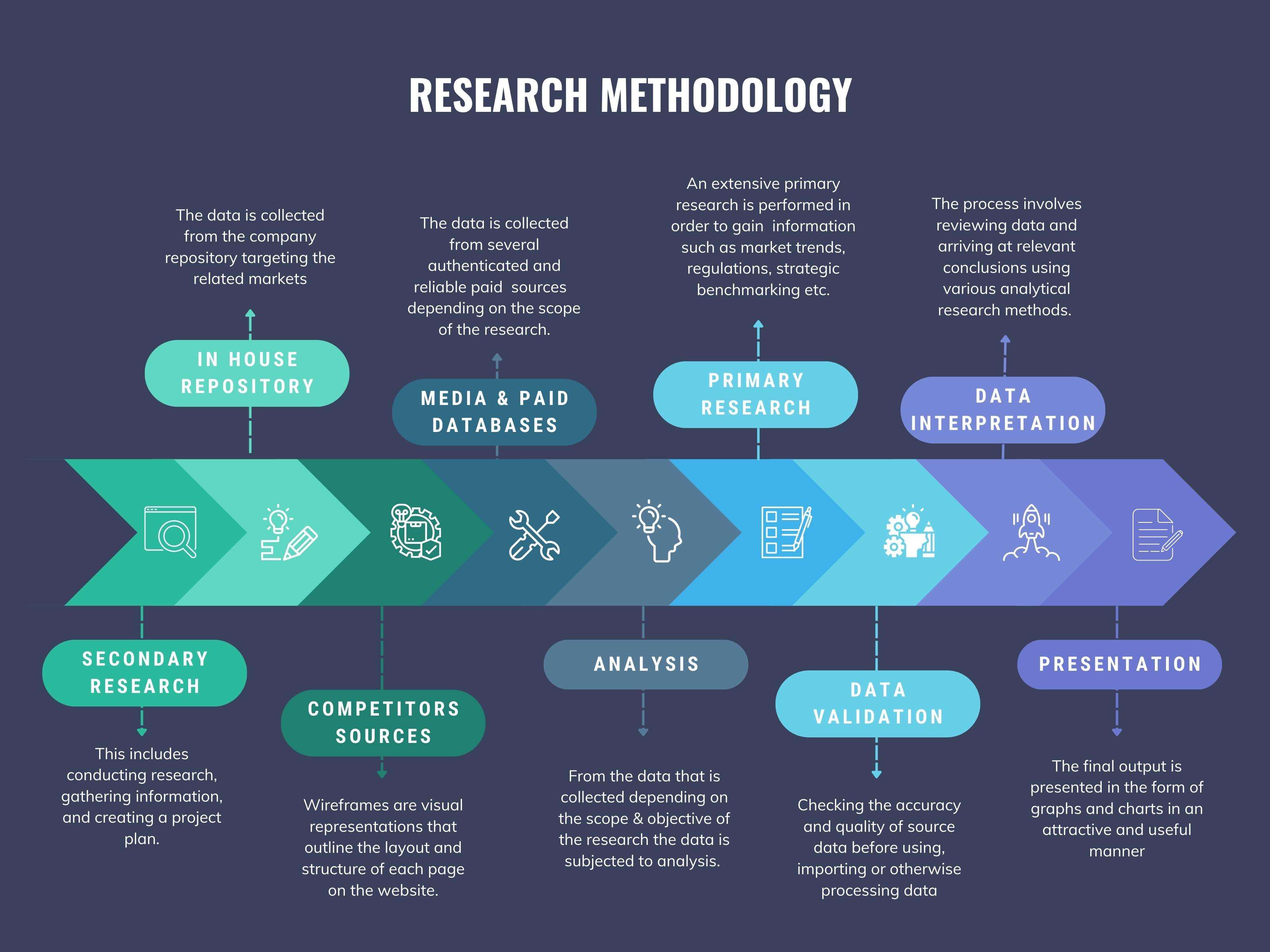
We at ‘Stratistics’ opt for an extensive research approach which involves data mining, data validation, and data analysis. The various research sources include in-house repository, secondary research, competitor’s sources, social media research, client internal data, and primary research.
Our team of analysts prefers the most reliable and authenticated data sources in order to perform the comprehensive literature search. With access to most of the authenticated data bases our team highly considers the best mix of information through various sources to obtain extensive and accurate analysis.
Each report takes an average time of a month and a team of 4 industry analysts. The time may vary depending on the scope and data availability of the desired market report. The various parameters used in the market assessment are standardized in order to enhance the data accuracy.
Data Mining
The data is collected from several authenticated, reliable, paid and unpaid sources and is filtered depending on the scope & objective of the research. Our reports repository acts as an added advantage in this procedure. Data gathering from the raw material suppliers, distributors and the manufacturers is performed on a regular basis, this helps in the comprehensive understanding of the products value chain. Apart from the above mentioned sources the data is also collected from the industry consultants to ensure the objective of the study is in the right direction.
Market trends such as technological advancements, regulatory affairs, market dynamics (Drivers, Restraints, Opportunities and Challenges) are obtained from scientific journals, market related national & international associations and organizations.
Data Analysis
From the data that is collected depending on the scope & objective of the research the data is subjected for the analysis. The critical steps that we follow for the data analysis include:
- Product Lifecycle Analysis
- Competitor analysis
- Risk analysis
- Porters Analysis
- PESTEL Analysis
- SWOT Analysis
The data engineering is performed by the core industry experts considering both the Marketing Mix Modeling and the Demand Forecasting. The marketing mix modeling makes use of multiple-regression techniques to predict the optimal mix of marketing variables. Regression factor is based on a number of variables and how they relate to an outcome such as sales or profits.
Data Validation
The data validation is performed by the exhaustive primary research from the expert interviews. This includes telephonic interviews, focus groups, face to face interviews, and questionnaires to validate our research from all aspects. The industry experts we approach come from the leading firms, involved in the supply chain ranging from the suppliers, distributors to the manufacturers and consumers so as to ensure an unbiased analysis.
We are in touch with more than 15,000 industry experts with the right mix of consultants, CEO's, presidents, vice presidents, managers, experts from both supply side and demand side, executives and so on.
The data validation involves the primary research from the industry experts belonging to:
- Leading Companies
- Suppliers & Distributors
- Manufacturers
- Consumers
- Industry/Strategic Consultants
Apart from the data validation the primary research also helps in performing the fill gap research, i.e. providing solutions for the unmet needs of the research which helps in enhancing the reports quality.
For more details about research methodology, kindly write to us at info@strategymrc.com
Frequently Asked Questions
In case of any queries regarding this report, you can contact the customer service by filing the “Inquiry Before Buy” form available on the right hand side. You may also contact us through email: info@strategymrc.com or phone: +1-301-202-5929
Yes, the samples are available for all the published reports. You can request them by filling the “Request Sample” option available in this page.
Yes, you can request a sample with your specific requirements. All the customized samples will be provided as per the requirement with the real data masked.
All our reports are available in Digital PDF format. In case if you require them in any other formats, such as PPT, Excel etc you can submit a request through “Inquiry Before Buy” form available on the right hand side. You may also contact us through email: info@strategymrc.com or phone: +1-301-202-5929
We offer a free 15% customization with every purchase. This requirement can be fulfilled for both pre and post sale. You may send your customization requirements through email at info@strategymrc.com or call us on +1-301-202-5929.
We have 3 different licensing options available in electronic format.
- Single User Licence: Allows one person, typically the buyer, to have access to the ordered product. The ordered product cannot be distributed to anyone else.
- 2-5 User Licence: Allows the ordered product to be shared among a maximum of 5 people within your organisation.
- Corporate License: Allows the product to be shared among all employees of your organisation regardless of their geographical location.
All our reports are typically be emailed to you as an attachment.
To order any available report you need to register on our website. The payment can be made either through CCAvenue or PayPal payments gateways which accept all international cards.
We extend our support to 6 months post sale. A post sale customization is also provided to cover your unmet needs in the report.
Request Customization
We offer complimentary customization of up to 15% with every purchase. To share your customization requirements, feel free to email us at info@strategymrc.com or call us on +1-301-202-5929. .
Please Note: Customization within the 15% threshold is entirely free of charge. If your request exceeds this limit, we will conduct a feasibility assessment. Following that, a detailed quote and timeline will be provided.
WHY CHOOSE US ?

Assured Quality
Best in class reports with high standard of research integrity

24X7 Research Support
Continuous support to ensure the best customer experience.

Free Customization
Adding more values to your product of interest.

Safe & Secure Access
Providing a secured environment for all online transactions.

Trusted by 600+ Brands
Serving the most reputed brands across the world.