Drone Crop Mapping Market
Drone Crop Mapping Market Forecasts to 2034 - Global Analysis By Drone Type (Fixed-Wing Drones, Rotary-Wing Drones, Hybrid Drones, and Nano & Micro Drones), Component, Crop Type, Deployment, Farm Size, Technology, Application, End User, and By Geography

According to Stratistics MRC, the Global Drone Crop Mapping Market is accounted for $3.8 billion in 2026 and is expected to reach $9.3 billion by 2034 growing at a CAGR of 11.8% during the forecast period. Drone crop mapping refers to the deployment of fixed-wing, rotary-wing, and hybrid unmanned aerial vehicle systems equipped with RGB cameras, multispectral sensors, hyperspectral imagers, thermal cameras, and LiDAR scanners to capture high-resolution aerial imagery and georeferenced data across agricultural fields, enabling precision agriculture practitioners to generate detailed crop health vegetation index maps, plant population counts, biomass estimates, disease and pest pressure zone maps, soil variability assessments, and yield prediction models that inform variable rate application prescriptions and agronomic management decisions.
Market Dynamics:
Driver:
Precision Agriculture Technology Adoption
Accelerating commercial farmer adoption of precision agriculture management practices requiring high-resolution crop spatial variability data is driving drone crop mapping adoption as the most cost-effective aerial data acquisition method for farm-scale field mapping at the spatial resolution and update frequency needed for effective variable rate fertilizer, irrigation, and pesticide application prescription generation. Documented input cost savings of 10 to 20 percent from variable rate application enabled by drone mapping data justify system investment for commercial grain and specialty crop producers.
Restraint:
Regulatory Flight Approval Complexity
Complex and fragmented drone flight regulatory frameworks across national and sub-national aviation authorities requiring operational approvals, pilot certification, airspace authorization, and beyond visual line of sight waivers for large-scale commercial agricultural drone mapping operations create operational overhead and compliance cost burdens that increase total drone crop mapping program cost and reduce operational flexibility compared to theoretical system capability, limiting adoption in jurisdictions with restrictive drone regulatory environments.
Opportunity:
Carbon Credit Verification Integration
Integration of drone crop mapping with agricultural carbon credit verification programs requiring spatial land cover, biomass, and crop establishment documentation represents a growing market opportunity as carbon program operators adopt drone imagery as a cost-effective field monitoring verification method that complements satellite imagery with higher resolution data collection capabilities required for rigorous carbon sequestration practice verification across agricultural land management carbon payment programs.
Threat:
Satellite Imagery Resolution Improvement
Rapid improvement in commercial satellite imagery spatial resolution from Planet Labs, Maxar, and emerging very high resolution satellite constellations delivering sub-meter agricultural imagery at scale is creating a competitive remote sensing alternative that challenges drone crop mapping adoption economics for broad-area field monitoring applications where satellite imagery can deliver adequate spatial resolution at substantially lower per-hectare data acquisition costs than drone-based survey programs.
Covid-19 Impact:
COVID-19 reduced agricultural advisor field visit frequency creating demand for remote crop monitoring technologies enabling field health assessment without physical site access during pandemic movement restrictions. Supply chain disruptions affecting equipment availability and labor access amplified precision agriculture technology adoption for remote farm management. Post-pandemic digital agriculture investment acceleration and precision farming mainstream adoption by commercial agricultural operators continue driving drone crop mapping market expansion.
The nano & micro drones segment is expected to be the largest during the forecast period
The nano & micro drones segment is expected to account for the largest market share during the forecast period, due to strong commercial farmer adoption of consumer and prosumer-grade compact drone systems from DJI, Parrot, and domestic manufacturers that provide cost-accessible entry points into drone crop mapping for small and medium agricultural operators, creating the largest installed base of mapping drone units despite lower average system prices compared to professional fixed-wing mapping drone platforms serving large commercial agricultural operations.
The hardware segment is expected to have the highest CAGR during the forecast period
Over the forecast period, the hardware segment is predicted to witness the highest growth rate, driven by continued expansion of drone crop mapping adoption creating sustained hardware procurement demand for drone airframes, multispectral sensor payloads, battery systems, and ground control station equipment, combined with technology advancement in precision agricultural drone hardware including longer-range fixed-wing platforms, improved multispectral sensor resolution, and integrated AI processing enabling on-board real-time crop analysis during mapping missions.
Region with largest share:
During the forecast period, the North America region is expected to hold the largest market share, due to the United States hosting large-scale commercial farming operations with high precision agriculture technology adoption, progressive FAA drone regulatory framework enabling commercial agricultural drone operations, leading precision agriculture technology companies including Trimble, Deere, and AgEagle generating substantial domestic drone crop mapping revenue, and strong agtech venture investment supporting drone mapping platform innovation.
Region with highest CAGR:
Over the forecast period, the Asia Pacific region is anticipated to exhibit the highest CAGR, due to China implementing large-scale government-supported agricultural drone adoption programs with XAG and DJI dominating domestic agricultural drone markets, India launching national precision agriculture programs supporting drone technology deployment across smallholder and commercial farming sectors, and rapidly growing precision horticulture and plantation crop management drone adoption across Southeast Asian agricultural markets.
Key players in the market
Some of the key players in Drone Crop Mapping Market include DJI, Parrot Drones, Trimble Inc., Deere & Company, AgEagle Aerial Systems, Sentera, XAG Co., Ltd., DroneDeploy, Pix4D, PrecisionHawk, Delair, Skycision, Airinov, Yamaha Motor Co., Ltd., Insitu (Boeing), AeroVironment, and EHang.
Key Developments:
In March 2026, DJI launched the Agras T60 agricultural drone featuring AI-powered crop scouting integration with automated multispectral mapping and pest detection capabilities for large-scale commercial crop production operations.
In February 2026, Pix4D introduced a new AI-powered precision agriculture mapping analytics platform providing automated NDVI analysis, plant count, and crop health zone mapping from drone imagery with same-day prescription generation.
In January 2026, AgEagle Aerial Systems secured a major precision agriculture partnership deploying its fixed-wing drone mapping system across a large US agricultural cooperative's member farm network for seasonal crop health monitoring services.
Drone Types Covered:
• Fixed-Wing Drones
• Rotary-Wing Drones
• Hybrid Drones
• Nano & Micro Drones
Components Covered:
• Hardware
• Software
• Services
Crop Types Covered:
• Cereals & Grains
• Fruits
• Vegetables
• Oilseeds
• Cash Crops
Deployments Covered:
• On-Premise
• Cloud-Based
Farm Sizes Covered:
• Small Farms
• Medium Farms
• Large Farms
Technologies Covered:
• Multispectral Imaging
• Hyperspectral Imaging
• Thermal Imaging
• LiDAR Mapping
• Photogrammetry
Applications Covered:
• Crop Health Monitoring
• Field Mapping & Surveying
• Precision Agriculture
• Irrigation Management
• Soil Analysis
• Yield Prediction
End Users Covered:
• Farmers
• Agricultural Service Providers
• Agribusiness Companies
• Government & Research Institutions
Regions Covered:
• North America
o United States
o Canada
o Mexico
• Europe
o United Kingdom
o Germany
o France
o Italy
o Spain
o Netherlands
o Belgium
o Sweden
o Switzerland
o Poland
o Rest of Europe
• Asia Pacific
o China
o Japan
o India
o South Korea
o Australia
o Indonesia
o Thailand
o Malaysia
o Singapore
o Vietnam
o Rest of Asia Pacific
• South America
o Brazil
o Argentina
o Colombia
o Chile
o Peru
o Rest of South America
• Rest of the World (RoW)
o Middle East
§ Saudi Arabia
§ United Arab Emirates
§ Qatar
§ Israel
§ Rest of Middle East
o Africa
§ South Africa
§ Egypt
§ Morocco
§ Rest of Africa
What our report offers:
- Market share assessments for the regional and country-level segments
- Strategic recommendations for the new entrants
- Covers Market data for the years 2023, 2024, 2025, 2026, 2027, 2028, 2030, 2032 and 2034
- Market Trends (Drivers, Constraints, Opportunities, Threats, Challenges, Investment Opportunities, and recommendations)
- Strategic recommendations in key business segments based on the market estimations
- Competitive landscaping mapping the key common trends
- Company profiling with detailed strategies, financials, and recent developments
- Supply chain trends mapping the latest technological advancements
Free Customization Offerings:
All the customers of this report will be entitled to receive one of the following free customization options:
• Company Profiling
o Comprehensive profiling of additional market players (up to 3)
o SWOT Analysis of key players (up to 3)
• Regional Segmentation
o Market estimations, Forecasts and CAGR of any prominent country as per the client's interest (Note: Depends on feasibility check)
• Competitive Benchmarking
Benchmarking of key players based on product portfolio, geographical presence, and strategic alliances
Table of Contents
1 Executive Summary
1.1 Market Snapshot and Key Highlights
1.2 Growth Drivers, Challenges, and Opportunities
1.3 Competitive Landscape Overview
1.4 Strategic Insights and Recommendations
2 Research Framework
2.1 Study Objectives and Scope
2.2 Stakeholder Analysis
2.3 Research Assumptions and Limitations
2.4 Research Methodology
2.4.1 Data Collection (Primary and Secondary)
2.4.2 Data Modeling and Estimation Techniques
2.4.3 Data Validation and Triangulation
2.4.4 Analytical and Forecasting Approach
3 Market Dynamics and Trend Analysis
3.1 Market Definition and Structure
3.2 Key Market Drivers
3.3 Market Restraints and Challenges
3.4 Growth Opportunities and Investment Hotspots
3.5 Industry Threats and Risk Assessment
3.6 Technology and Innovation Landscape
3.7 Emerging and High-Growth Markets
3.8 Regulatory and Policy Environment
3.9 Impact of COVID-19 and Recovery Outlook
4 Competitive and Strategic Assessment
4.1 Porter's Five Forces Analysis
4.1.1 Supplier Bargaining Power
4.1.2 Buyer Bargaining Power
4.1.3 Threat of Substitutes
4.1.4 Threat of New Entrants
4.1.5 Competitive Rivalry
4.2 Market Share Analysis of Key Players
4.3 Product Benchmarking and Performance Comparison
5 Global Drone Crop Mapping Market, By Drone Type
5.1 Fixed-Wing Drones
5.2 Rotary-Wing Drones
5.3 Hybrid Drones
5.4 Nano & Micro Drones
6 Global Drone Crop Mapping Market, By Component
6.1 Hardware
6.1.1 Cameras & Sensors
6.1.2 GPS & Navigation Systems
6.1.3 Batteries
6.2 Software
6.2.1 Mapping & Imaging Software
6.2.2 AI & Analytics Platforms
6.3 Services
6.3.1 Data Processing Services
6.3.2 Consulting & Support
7 Global Drone Crop Mapping Market, By Crop Type
7.1 Cereals & Grains
7.2 Fruits
7.3 Vegetables
7.4 Oilseeds
7.5 Cash Crops
8 Global Drone Crop Mapping Market, By Deployment
8.1 On-Premise
8.2 Cloud-Based
9 Global Drone Crop Mapping Market, By Farm Size
9.1 Small Farms
9.2 Medium Farms
9.3 Large Farms
10 Global Drone Crop Mapping Market, By Technology
10.1 Multispectral Imaging
10.2 Hyperspectral Imaging
10.3 Thermal Imaging
10.4 LiDAR Mapping
10.5 Photogrammetry
11 Global Drone Crop Mapping Market, By Application
11.1 Crop Health Monitoring
11.2 Field Mapping & Surveying
11.3 Precision Agriculture
11.4 Irrigation Management
11.5 Soil Analysis
11.6 Yield Prediction
12 Global Drone Crop Mapping Market, By End User
12.1 Farmers
12.2 Agricultural Service Providers
12.3 Agribusiness Companies
12.4 Government & Research Institutions
13 Global Drone Crop Mapping Market, By Geography
13.1 North America
13.1.1 United States
13.1.2 Canada
13.1.3 Mexico
13.2 Europe
13.2.1 United Kingdom
13.2.2 Germany
13.2.3 France
13.2.4 Italy
13.2.5 Spain
13.2.6 Netherlands
13.2.7 Belgium
13.2.8 Sweden
13.2.9 Switzerland
13.2.10 Poland
13.2.11 Rest of Europe
13.3 Asia Pacific
13.3.1 China
13.3.2 Japan
13.3.3 India
13.3.4 South Korea
13.3.5 Australia
13.3.6 Indonesia
13.3.7 Thailand
13.3.8 Malaysia
13.3.9 Singapore
13.3.10 Vietnam
13.3.11 Rest of Asia Pacific
13.4 South America
13.4.1 Brazil
13.4.2 Argentina
13.4.3 Colombia
13.4.4 Chile
13.4.5 Peru
13.4.6 Rest of South America
13.5 Rest of the World (RoW)
13.5.1 Middle East
13.5.1.1 Saudi Arabia
13.5.1.2 United Arab Emirates
13.5.1.3 Qatar
13.5.1.4 Israel
13.5.1.5 Rest of Middle East
13.5.2 Africa
13.5.2.1 South Africa
13.5.2.2 Egypt
13.5.2.3 Morocco
13.5.2.4 Rest of Africa
14 Strategic Market Intelligence
14.1 Industry Value Network and Supply Chain Assessment
14.2 White-Space and Opportunity Mapping
14.3 Product Evolution and Market Life Cycle Analysis
14.4 Channel, Distributor, and Go-to-Market Assessment
15 Industry Developments and Strategic Initiatives
15.1 Mergers and Acquisitions
15.2 Partnerships, Alliances, and Joint Ventures
15.3 New Product Launches and Certifications
15.4 Capacity Expansion and Investments
15.5 Other Strategic Initiatives
16 Company Profiles
16.1 DJI
16.2 Parrot Drones
16.3 Trimble Inc.
16.4 Deere & Company
16.5 AgEagle Aerial Systems
16.6 Sentera
16.7 XAG Co., Ltd.
16.8 DroneDeploy
16.9 Pix4D
16.10 PrecisionHawk
16.11 Delair
16.12 Skycision
16.13 Airinov
16.14 Yamaha Motor Co., Ltd.
16.15 Insitu (Boeing)
16.16 AeroVironment
16.17 EHang
List of Tables
1 Global Drone Crop Mapping Market Outlook, By Region (2023-2034) ($MN)
2 Global Drone Crop Mapping Market Outlook, By Drone Type (2023-2034) ($MN)
3 Global Drone Crop Mapping Market Outlook, By Fixed-Wing Drones (2023-2034) ($MN)
4 Global Drone Crop Mapping Market Outlook, By Rotary-Wing Drones (2023-2034) ($MN)
5 Global Drone Crop Mapping Market Outlook, By Hybrid Drones (2023-2034) ($MN)
6 Global Drone Crop Mapping Market Outlook, By Nano & Micro Drones (2023-2034) ($MN)
7 Global Drone Crop Mapping Market Outlook, By Component (2023-2034) ($MN)
8 Global Drone Crop Mapping Market Outlook, By Hardware (2023-2034) ($MN)
9 Global Drone Crop Mapping Market Outlook, By Cameras & Sensors (2023-2034) ($MN)
10 Global Drone Crop Mapping Market Outlook, By GPS & Navigation Systems (2023-2034) ($MN)
11 Global Drone Crop Mapping Market Outlook, By Batteries (2023-2034) ($MN)
12 Global Drone Crop Mapping Market Outlook, By Software (2023-2034) ($MN)
13 Global Drone Crop Mapping Market Outlook, By Mapping & Imaging Software (2023-2034) ($MN)
14 Global Drone Crop Mapping Market Outlook, By AI & Analytics Platforms (2023-2034) ($MN)
15 Global Drone Crop Mapping Market Outlook, By Services (2023-2034) ($MN)
16 Global Drone Crop Mapping Market Outlook, By Data Processing Services (2023-2034) ($MN)
17 Global Drone Crop Mapping Market Outlook, By Consulting & Support (2023-2034) ($MN)
18 Global Drone Crop Mapping Market Outlook, By Crop Type (2023-2034) ($MN)
19 Global Drone Crop Mapping Market Outlook, By Cereals & Grains (2023-2034) ($MN)
20 Global Drone Crop Mapping Market Outlook, By Fruits (2023-2034) ($MN)
21 Global Drone Crop Mapping Market Outlook, By Vegetables (2023-2034) ($MN)
22 Global Drone Crop Mapping Market Outlook, By Oilseeds (2023-2034) ($MN)
23 Global Drone Crop Mapping Market Outlook, By Cash Crops (2023-2034) ($MN)
24 Global Drone Crop Mapping Market Outlook, By Deployment (2023-2034) ($MN)
25 Global Drone Crop Mapping Market Outlook, By On-Premise (2023-2034) ($MN)
26 Global Drone Crop Mapping Market Outlook, By Cloud-Based (2023-2034) ($MN)
27 Global Drone Crop Mapping Market Outlook, By Farm Size (2023-2034) ($MN)
28 Global Drone Crop Mapping Market Outlook, By Small Farms (2023-2034) ($MN)
29 Global Drone Crop Mapping Market Outlook, By Medium Farms (2023-2034) ($MN)
30 Global Drone Crop Mapping Market Outlook, By Large Farms (2023-2034) ($MN)
31 Global Drone Crop Mapping Market Outlook, By Technology (2023-2034) ($MN)
32 Global Drone Crop Mapping Market Outlook, By Multispectral Imaging (2023-2034) ($MN)
33 Global Drone Crop Mapping Market Outlook, By Hyperspectral Imaging (2023-2034) ($MN)
34 Global Drone Crop Mapping Market Outlook, By Thermal Imaging (2023-2034) ($MN)
35 Global Drone Crop Mapping Market Outlook, By LiDAR Mapping (2023-2034) ($MN)
36 Global Drone Crop Mapping Market Outlook, By Photogrammetry (2023-2034) ($MN)
37 Global Drone Crop Mapping Market Outlook, By Application (2023-2034) ($MN)
38 Global Drone Crop Mapping Market Outlook, By Crop Health Monitoring (2023-2034) ($MN)
39 Global Drone Crop Mapping Market Outlook, By Field Mapping & Surveying (2023-2034) ($MN)
40 Global Drone Crop Mapping Market Outlook, By Precision Agriculture (2023-2034) ($MN)
41 Global Drone Crop Mapping Market Outlook, By Irrigation Management (2023-2034) ($MN)
42 Global Drone Crop Mapping Market Outlook, By Soil Analysis (2023-2034) ($MN)
43 Global Drone Crop Mapping Market Outlook, By Yield Prediction (2023-2034) ($MN)
44 Global Drone Crop Mapping Market Outlook, By End User (2023-2034) ($MN)
45 Global Drone Crop Mapping Market Outlook, By Farmers (2023-2034) ($MN)
46 Global Drone Crop Mapping Market Outlook, By Agricultural Service Providers (2023-2034) ($MN)
47 Global Drone Crop Mapping Market Outlook, By Agribusiness Companies (2023-2034) ($MN)
48 Global Drone Crop Mapping Market Outlook, By Government & Research Institutions (2023-2034) ($MN)
Note: Tables for North America, Europe, APAC, South America, and Rest of the World (RoW) Regions are also represented in the same manner as above.
List of Figures
RESEARCH METHODOLOGY
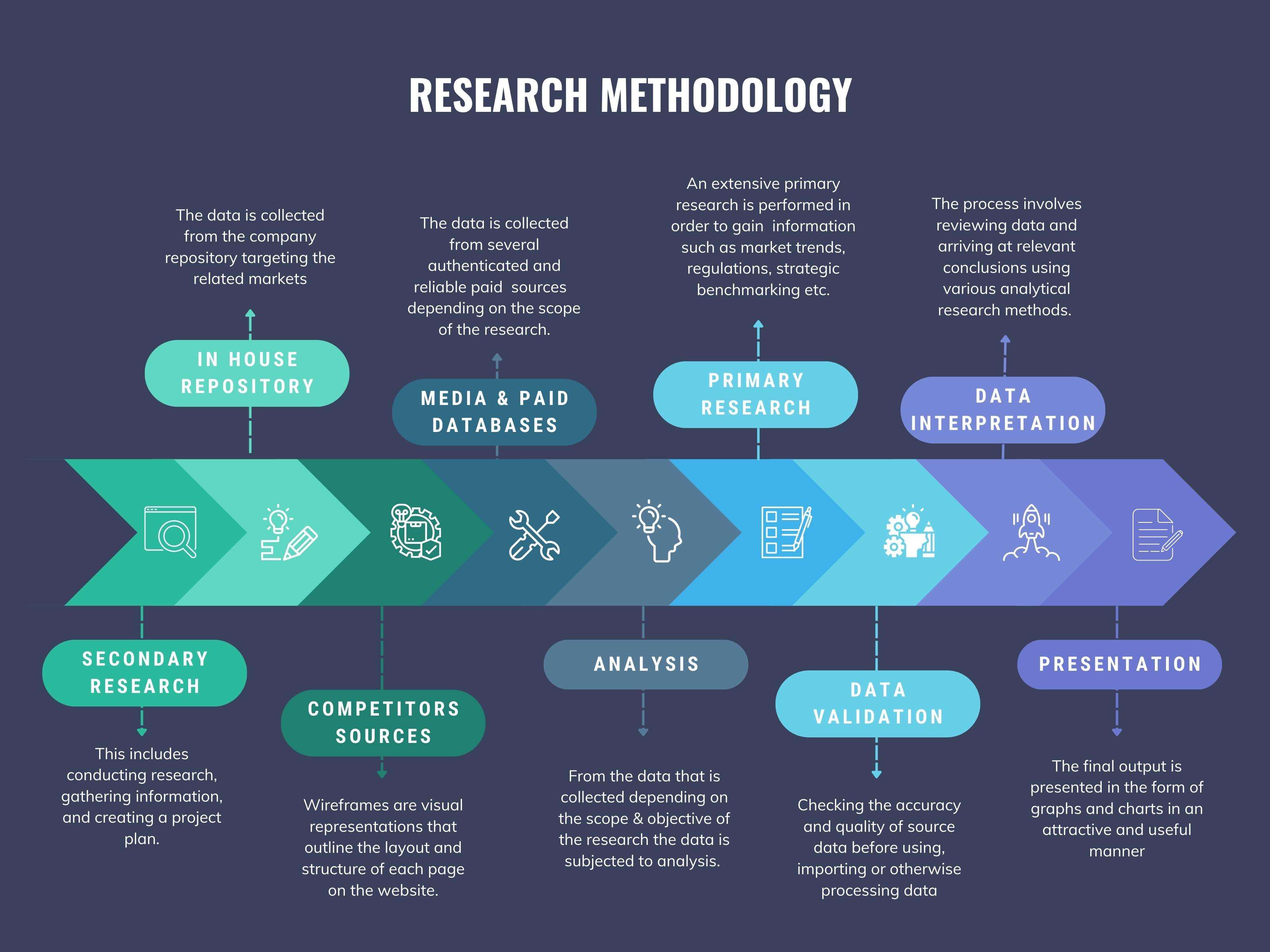
We at ‘Stratistics’ opt for an extensive research approach which involves data mining, data validation, and data analysis. The various research sources include in-house repository, secondary research, competitor’s sources, social media research, client internal data, and primary research.
Our team of analysts prefers the most reliable and authenticated data sources in order to perform the comprehensive literature search. With access to most of the authenticated data bases our team highly considers the best mix of information through various sources to obtain extensive and accurate analysis.
Each report takes an average time of a month and a team of 4 industry analysts. The time may vary depending on the scope and data availability of the desired market report. The various parameters used in the market assessment are standardized in order to enhance the data accuracy.
Data Mining
The data is collected from several authenticated, reliable, paid and unpaid sources and is filtered depending on the scope & objective of the research. Our reports repository acts as an added advantage in this procedure. Data gathering from the raw material suppliers, distributors and the manufacturers is performed on a regular basis, this helps in the comprehensive understanding of the products value chain. Apart from the above mentioned sources the data is also collected from the industry consultants to ensure the objective of the study is in the right direction.
Market trends such as technological advancements, regulatory affairs, market dynamics (Drivers, Restraints, Opportunities and Challenges) are obtained from scientific journals, market related national & international associations and organizations.
Data Analysis
From the data that is collected depending on the scope & objective of the research the data is subjected for the analysis. The critical steps that we follow for the data analysis include:
- Product Lifecycle Analysis
- Competitor analysis
- Risk analysis
- Porters Analysis
- PESTEL Analysis
- SWOT Analysis
The data engineering is performed by the core industry experts considering both the Marketing Mix Modeling and the Demand Forecasting. The marketing mix modeling makes use of multiple-regression techniques to predict the optimal mix of marketing variables. Regression factor is based on a number of variables and how they relate to an outcome such as sales or profits.
Data Validation
The data validation is performed by the exhaustive primary research from the expert interviews. This includes telephonic interviews, focus groups, face to face interviews, and questionnaires to validate our research from all aspects. The industry experts we approach come from the leading firms, involved in the supply chain ranging from the suppliers, distributors to the manufacturers and consumers so as to ensure an unbiased analysis.
We are in touch with more than 15,000 industry experts with the right mix of consultants, CEO's, presidents, vice presidents, managers, experts from both supply side and demand side, executives and so on.
The data validation involves the primary research from the industry experts belonging to:
- Leading Companies
- Suppliers & Distributors
- Manufacturers
- Consumers
- Industry/Strategic Consultants
Apart from the data validation the primary research also helps in performing the fill gap research, i.e. providing solutions for the unmet needs of the research which helps in enhancing the reports quality.
For more details about research methodology, kindly write to us at info@strategymrc.com
Frequently Asked Questions
In case of any queries regarding this report, you can contact the customer service by filing the “Inquiry Before Buy” form available on the right hand side. You may also contact us through email: info@strategymrc.com or phone: +1-301-202-5929
Yes, the samples are available for all the published reports. You can request them by filling the “Request Sample” option available in this page.
Yes, you can request a sample with your specific requirements. All the customized samples will be provided as per the requirement with the real data masked.
All our reports are available in Digital PDF format. In case if you require them in any other formats, such as PPT, Excel etc you can submit a request through “Inquiry Before Buy” form available on the right hand side. You may also contact us through email: info@strategymrc.com or phone: +1-301-202-5929
We offer a free 15% customization with every purchase. This requirement can be fulfilled for both pre and post sale. You may send your customization requirements through email at info@strategymrc.com or call us on +1-301-202-5929.
We have 3 different licensing options available in electronic format.
- Single User Licence: Allows one person, typically the buyer, to have access to the ordered product. The ordered product cannot be distributed to anyone else.
- 2-5 User Licence: Allows the ordered product to be shared among a maximum of 5 people within your organisation.
- Corporate License: Allows the product to be shared among all employees of your organisation regardless of their geographical location.
All our reports are typically be emailed to you as an attachment.
To order any available report you need to register on our website. The payment can be made either through CCAvenue or PayPal payments gateways which accept all international cards.
We extend our support to 6 months post sale. A post sale customization is also provided to cover your unmet needs in the report.
Request Customization
We offer complimentary customization of up to 15% with every purchase. To share your customization requirements, feel free to email us at info@strategymrc.com or call us on +1-301-202-5929. .
Please Note: Customization within the 15% threshold is entirely free of charge. If your request exceeds this limit, we will conduct a feasibility assessment. Following that, a detailed quote and timeline will be provided.
WHY CHOOSE US ?

Assured Quality
Best in class reports with high standard of research integrity

24X7 Research Support
Continuous support to ensure the best customer experience.

Free Customization
Adding more values to your product of interest.

Safe & Secure Access
Providing a secured environment for all online transactions.

Trusted by 600+ Brands
Serving the most reputed brands across the world.